Skip to content
Menu
Backcountry Fever
  • Projects
    • Adirondack 46ers
    • Colorado 14ers
    • Seven Summits
      • Climb Aconcagua via the 360° Traverse | Full Guide
    • Wasatch 7
    • Wasatch 11ers
  • Highpoints
  • Experience
  • My Never-Ending List
  • Contact
Backcountry Fever
← From Citlaltépetl to Iztaccíhuatl
To Be, Or Not To Be… Guided, That Is →

Traversing Mexico’s Sleeping Beauty

Posted on January 10, 2024October 22, 2025 by Backcountry Fever

DAY 8 – Izta Summit Day

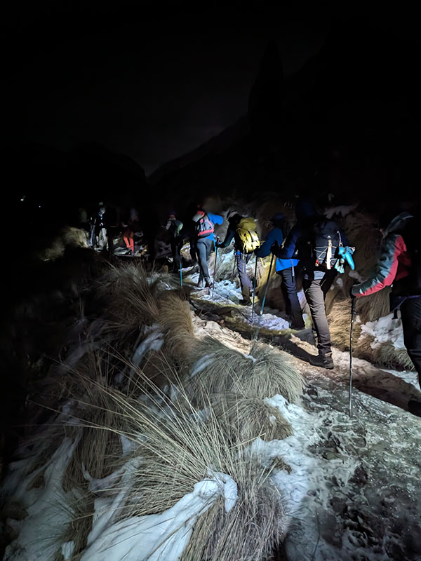
Midnight came quickly as it always does.  Not sure why we had to start that early again and our guides really didn’t have a good answer.  We only had 4,000′ of elevation in 4 miles, very much like a typical day in Utah.  Granted, we were starting from 13,000′ and would climb to 17K but that still didn’t seem to necessitate another 1 a.m. start.  Unfortunately, the only option here was to follow along.  When your group hires a guide, the team loses all decision making ability… which I have very mixed feelings about.

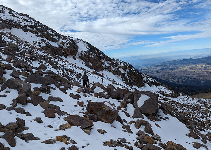
Up by way of La Arista de Sol

Within 15 minutes of hiking La Arista de Sol, the standard route on Izta, we were already passing a large group that started shortly before us.  We would not see them again.

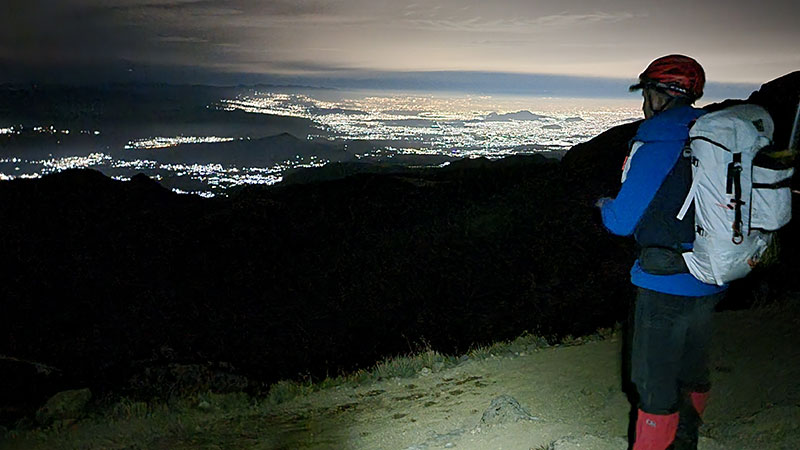
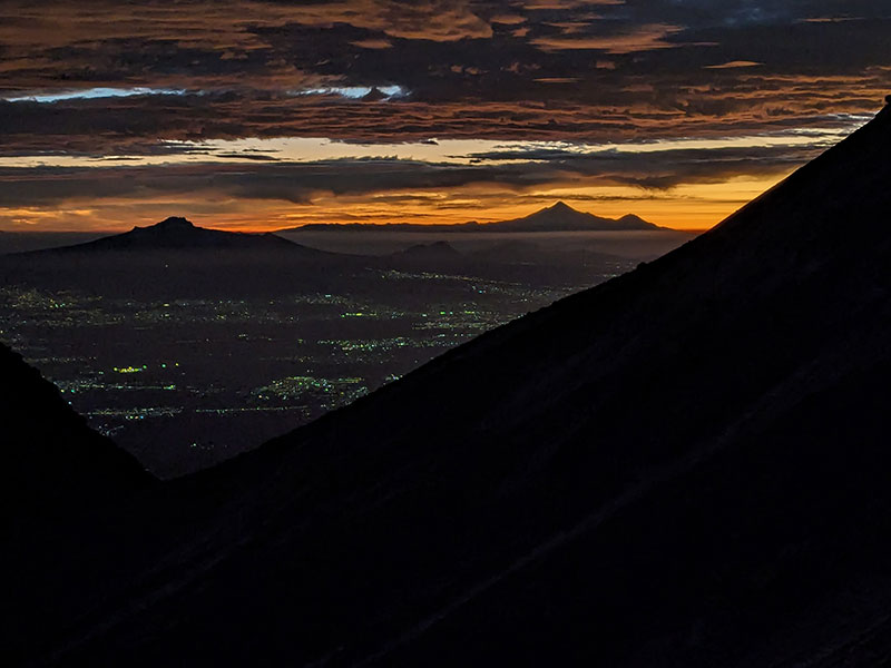
1,000 feet up and a mile in, we reached the 1st saddle in just under an hour.  400 more feet and another third of a mile and we hit the 2nd saddle.   The lights of Mexico City could be seen off in the distance.

When we got to the 3rd saddle at 14,860′, we had climbed 1,800′ in 1.75 miles.  That elevation and distance took us 2 hours.  It felt like we were making decent progress but slow and steady was the pace.

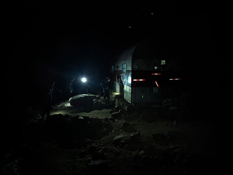
By 4 a.m., we made it to the Grupo de Los Cien shelter at 15,500 feet.  We were 2,500′ up and almost 2.5 miles in after 3 hours of climbing in those cold, dark morning hours.
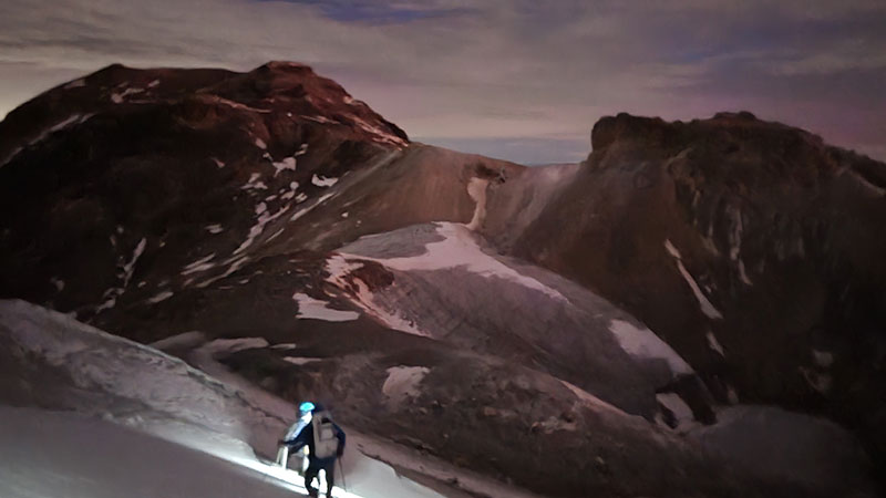
Not Really The Crux

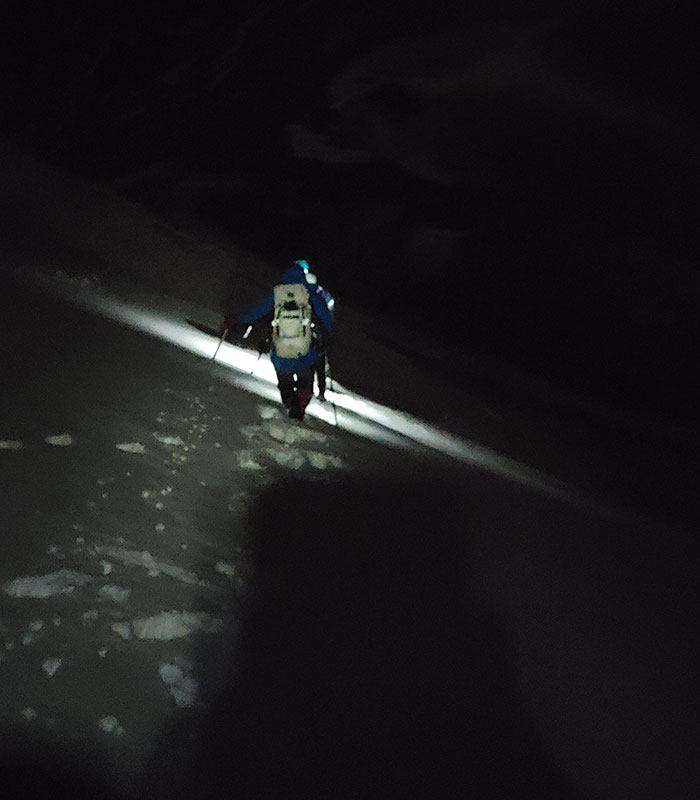
The slope up from this hut to The Knees is supposed to be the crux of this route.  I would challenge that opinion with what we thought to be a real crux later.  This section of the climb does ascend 1,000′ in a half mile to the First Knee at 16,500′.  So it’s definitely steep, but hardly required use of your hands to make it.  The risk level also didn’t seem high as far as the probability of slipping and falling to your doom.  Maybe that would have felt different with more light, but I doubt it.  I also don’t recall seeing any crosses here either.  Again, this would have been much better to do with more daylight.

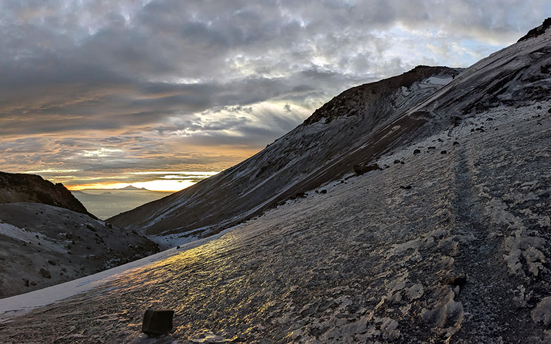
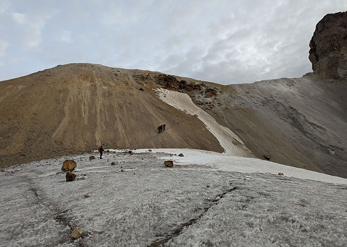
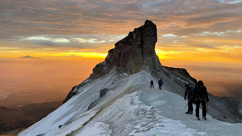
A quarter mile later and another 200′ of elevation, we reached The Belly.  Before dropping down onto that glacier, we stopped to throw on crampons.  It was the first bit of snow we came across all morning.

Shortly thereafter, the sunrise from this vantage point was unbelievable.  We were in the right place at the right time to see it light up the sky behind Malinche and Orizaba.  A Van Halen song came to mind!

This is also where we came upon the real crux.

The Real Crux

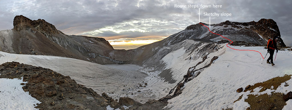
As we were setting up camp the day before, a couple from Seattle had returned from their summit day.  We, of course, asked how it was, anxious to know more about what to expect firsthand.  Both expressed that “The crux wasn’t the crux at all.  The real crux was after that – down the sheet of ice into the belly.”  We concur… the “crux” up to The Knee was nothing!  The real crux, as we traversed it, was definitely this slope the Seattle climbers warned about.  It was solid ice!  Obviously there are no pictures of that white-knuckle experience until after we passed the worst of it seen below.

The sketchy part is the upper slope where you can see two others coming down behind us (circled).

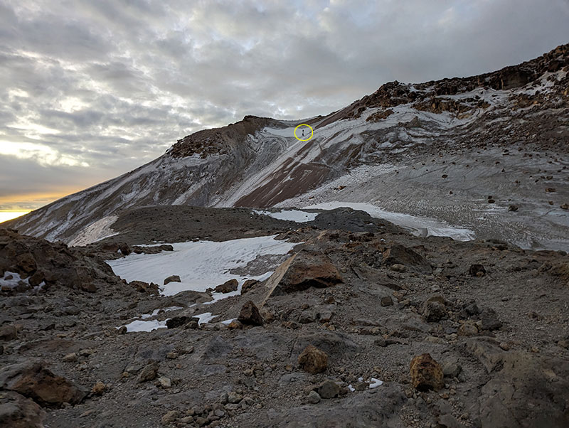
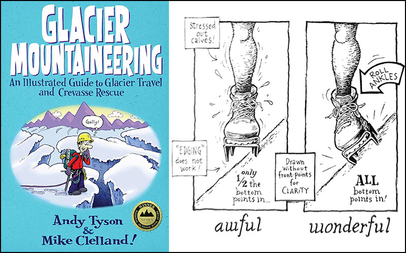
Safe crossing here required careful footwork since an ice axe would have done absolutely nothing!  I had never been on such an extreme surface before and remembered reading about this in Glacier Mountaineering by Andy Tyson & Mike Clelland.  ALL TWELVE POINTS needed to be engaged, 100%!

Our guide told us Glaciar del Vientre has receded much over the years.  Way back whenever, you could cut right across rather than having to go around like we did.

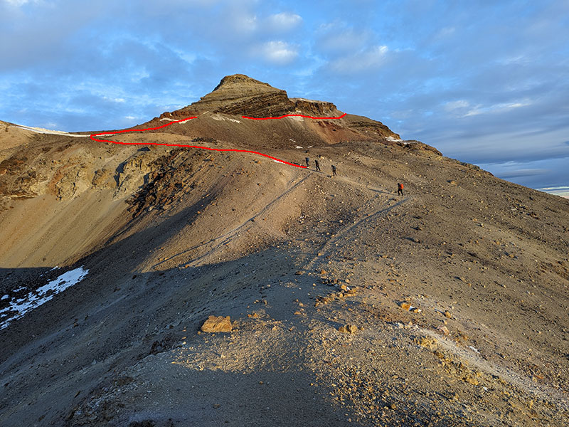
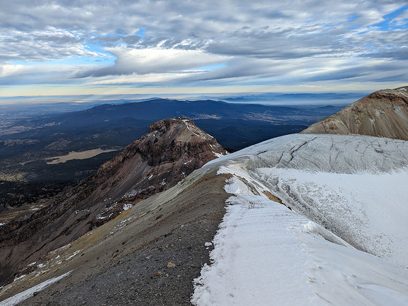
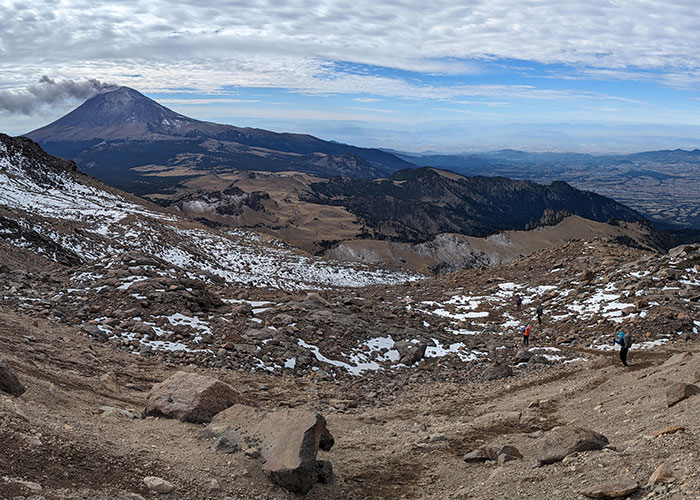
Up and out of The Belly to that ridgeline above.

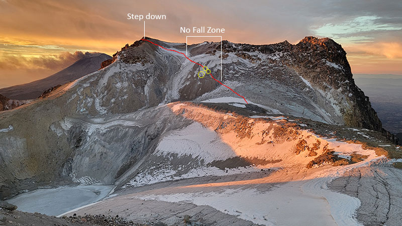
From there, we looked back at what we later considered a “no fall zone”.  Four more climbers were crossing that area as this pic was taken.  They are circled for further perspective about that being the real crux of the route.  If there was a better way across this section, our guide didn’t lead us there.

A few more shots were taken of this sunrise while the clouds filtered its colors.

Final Push

The final push is only a half mile more from here to The Breast (“here”, meaning the top of the ridgeline after climbing up out of The Belly, as seen above).  Another 400 feel of elevation is gained in this final stretch pictured behind our guide below.

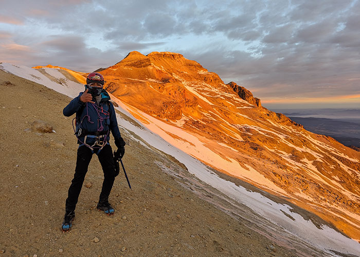
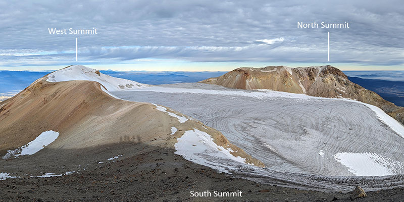
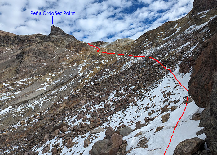
Up and around this bump called Peña Ordoñez according to the CalTopo map I’m referencing… and no, that’s not a nipple of this iztāc (white) cihuātl (woman).

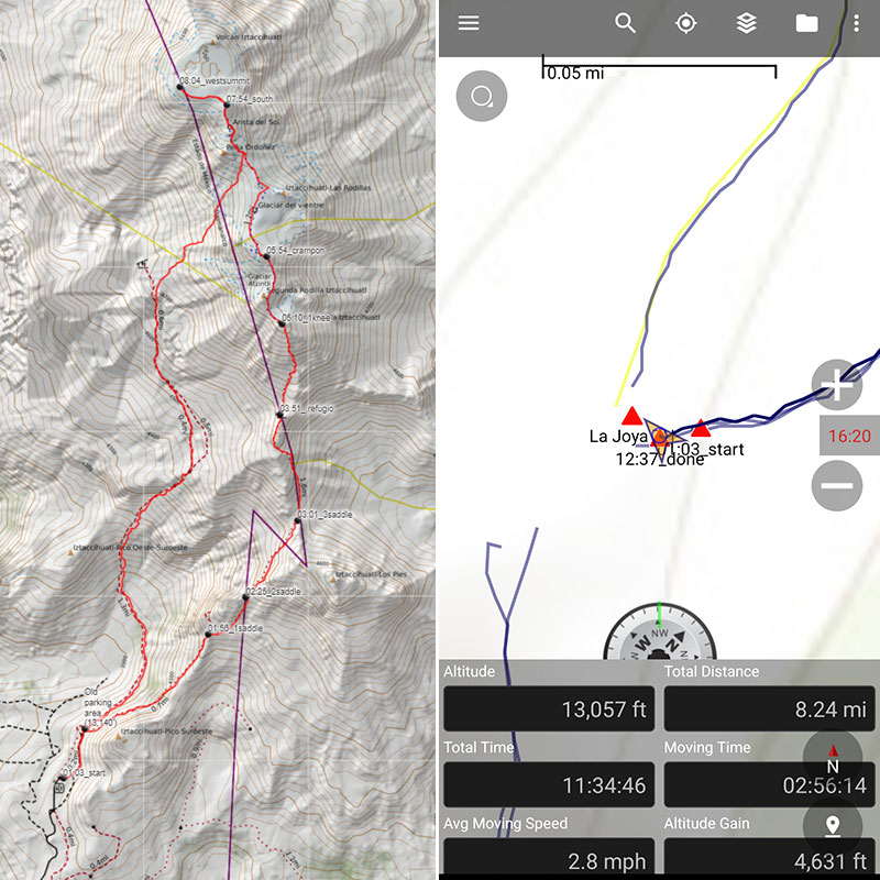
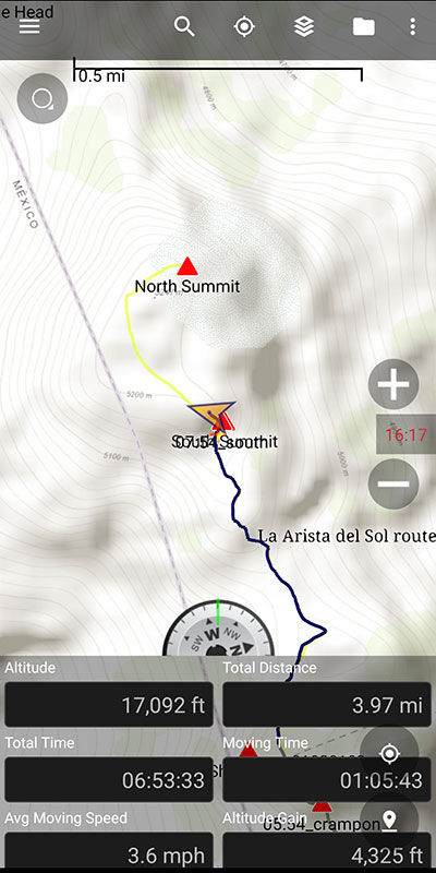
We reached the South Summit a few minutes before 8 o’clock.  That put our summit stats at slightly under 7 hours to climb 4,300 feet in 4 miles.

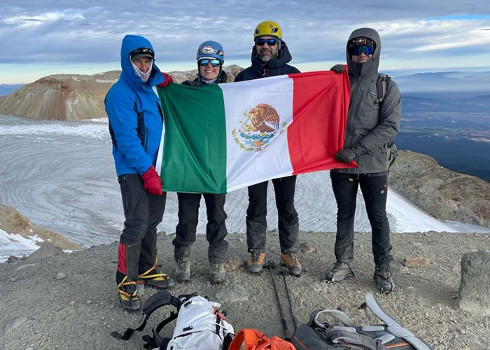
We did wander over to the West Summit to see The Head of this sleeping beauty.

However, there was no desire to cross over and touch the North Summit.  It was cold and windy and we were ready to be done.  We were standing on the highest point, and that was really all that mattered.

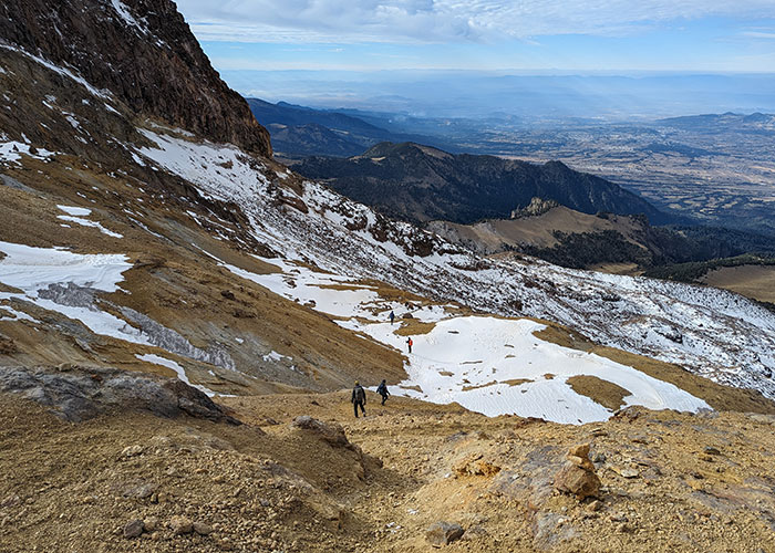
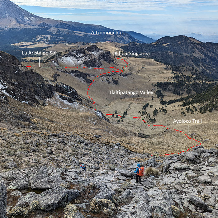
Down by way of Ayoloco

Our guide suggested an alternate way down instead of going back the way we came.  It’s called the Ayoloco Trail.  It drops off the ridge to the west just after that bump called Peña Ordoñez on CalTopo.

Looking back at what we just started to descend, Peña Ordoñez is that rocky point best seen here.

Ayoloco Trail

With nothing much left of the Glacier de Ayoloco, the traverse is through large boulders as you cross this field of moraine.  The map does show another shelter in this area called Refugio de Ayoloco, but we didn’t take the time to go look.

It mellows out the closer you get to the valley floor.

The Ayoloco route is a pretty steady descent for 3.5 miles.  At about a thousand feet per mile, I don’t think it would be too bad going up to the summit this way.

We arrived back at Camp La Joya around 12:30, just in time for lunch.  Final stats for the day were 4,600 feet over 8 miles in 11 and a half hours.  Our GPX track can be downloaded from here.

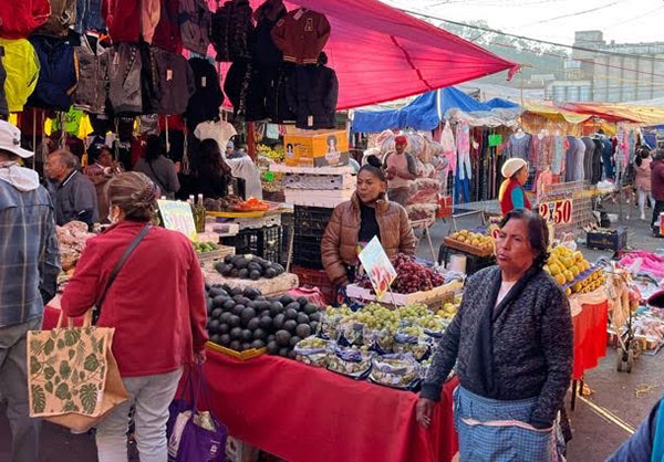
Two hours later, the last member of our group arrived back at camp.  We kinda had to rush her to get changed, packed up and loaded in the van that would take us back to Mexico City.  I started to realize that this might be why guides make you start so early.  They have no idea how long it’s going to take their clients to finish.  I’m sure the Servimont staff expected to leave right after lunch, but instead, had to sit around and wait for a couple more hours.  However, we still were able to make a quick stop in Amecameca to check out their local street market.

We spent our last night back where we started, at the Fiesta Inn near the airport.  Their dinner buffet, a nice hot shower and a comfy bed with a normal pillow made for a really nice ending.

DAY 9 – Return Home

My flight left early that next morning… like 5:45am.  Others were scheduled to leave throughout the day, but I didn’t mind this “alpine start”.  It put me in Houston at 8 and back home by noon.  Reflecting on the week, it was a pretty awesome trip!

← From Citlaltépetl to Iztaccíhuatl
To Be, Or Not To Be… Guided, That Is →

Leave a Reply Cancel reply

Your email address will not be published. Required fields are marked *

Awesome views from the top of Y Mountain. Looking north into Rock Canyon, where I started, and across towards the old Squaw Peak, Cascade Mountain, and Mount Timpanogos further off in the distance.

Pretty fun loop hike 👇

- Up 1.8 miles from the Rock Canyon trailhead
- Up 1.8 miles on First Right Fork to Slide Canyon
- Down Slide Canyon Trail .5 miles to Y Mountain Trail
- Up 1 mile to Y Mountain West Peak
- Down .25 and over .25 miles to Y Mountain East Peak
- Down 1 mile back to Slide Canyon Trail
- Down 1.5 miles to Y Trail (top of the BYU Y)
- Down 1 mile to the Y Trail trailhead
- Across 1.75 miles on the Bonneville Shoreline Trail

For a total of 10.75 miles with 4,137 feet of elevation gain.

#ymountain #rockcanyon #rockcanyontrail #firstrightfork #slidecanyon #ytrail #ytrailhead #bst #bonnevilleshorelinetrail #bonnevilleshoreline #connector #loophike #wasatchfront #hikethewasatch #wasatchmountains #wasatch #hike #hikemore

31 1
Open post by backcountryfever with ID 17900152413305912
Awesome views from the top of Y Mountain.  Looking north into Rock Canyon, where I started, and across towards the old Squaw Peak, Cascade Mountain, and Mount Timpanogos further off in the distance. 

Pretty fun loop hike 👇

- Up 1.8 miles from the Rock Canyon trailhead
- Up 1.8 miles on First Right Fork to Slide Canyon
- Down Slide Canyon Trail .5 miles to Y Mountain Trail
- Up 1 mile to Y Mountain West Peak 
- Down .25 and over .25 miles to Y Mountain East Peak
- Down 1 mile back to Slide Canyon Trail
- Down 1.5 miles to Y Trail (top of the BYU Y)
- Down 1 mile to the Y Trail trailhead
- Across 1.75 miles on the Bonneville Shoreline Trail

For a total of 10.75 miles with 4,137 feet of elevation gain.

#ymountain #rockcanyon #rockcanyontrail #firstrightfork #slidecanyon #ytrail #ytrailhead #bst #bonnevilleshorelinetrail #bonnevilleshoreline #connector #loophike #wasatchfront #hikethewasatch #wasatchmountains #wasatch #hike #hikemore

As the seasons change, each quiet mile through these trees feels like an invitation to let go of what was and move toward all that`s yet to come...

#seasonschange #lettinggo #movingon #pressingforward #lookingahead #newbeginnings #natureishealing #healingenergy #goodvibes #autumnvibes #autumnmountains #hiking #hikerlife #mountainlife #mountains

25 0
Open post by backcountryfever with ID 17902202193279047
As the seasons change, each quiet mile through these trees feels like an invitation to let go of what was and move toward all that's yet to come...

#seasonschange #lettinggo #movingon #pressingforward #lookingahead #newbeginnings #natureishealing #healingenergy #goodvibes #autumnvibes #autumnmountains #hiking #hikerlife #mountainlife #mountains

Fall colors are fading fast, losing the battle with winter.

#fallcolors #fadingfast #autumn #hikingtrails #hiking #hike #hiker #getreadyforwinter

14 0
Open post by backcountryfever with ID 17913756879229216
Fall colors are fading fast, losing the battle with winter.

#fallcolors #fadingfast #autumn #hikingtrails #hiking #hike #hiker #getreadyforwinter

I had high hopes of doing some hiking during a recent trip to O`ahu.  Unfortunately, a lower leg injury from a Summer Hockey League playoff game last month left me hobbling around just enough to make the trip, but not much else.  

This is what I was hoping to explore while spending 10 days on O`ahu for the first time.  I also knew I wouldn`t get to all of them in one trip — especially with other things we wanted to do — so here they are in order of priority:

- Backway for the Stairway to Heaven (Haiku Stairs)
- Three Peaks (Mt. Olomana)
- Reverse Olomana Trail
- Makapu`u Lighthouse Trail
- Koko Crater Stairs
- Koko Crater Rim Trail
- Diamond Head Crater Trail
- Old Pali Highway
- Mt. Ka`ala (tallest peak on O`ahu)
- Pūpūkea to La`ie
 
Maybe next time...

#hikehawaii #hawaiihiking #oahu #stairwaytoheaven #haikustairs #threepeaks #olomana #kokocrater #rimtrail #oldpalihighway #mtkaala #lowerleginjury #musclestrain #tibialisanterior #hockey

24 4
Open post by backcountryfever with ID 18403849120137976
I had high hopes of doing some hiking during a recent trip to O'ahu.  Unfortunately, a lower leg injury from a Summer Hockey League playoff game last month left me hobbling around just enough to make the trip, but not much else.   

This is what I was hoping to explore while spending 10 days on O'ahu for the first time.  I also knew I wouldn't get to all of them in one trip — especially with other things we wanted to do — so here they are in order of priority:

- Backway for the Stairway to Heaven (Haiku Stairs)
- Three Peaks (Mt. Olomana)
- Reverse Olomana Trail
- Makapu'u Lighthouse Trail
- Koko Crater Stairs
- Koko Crater Rim Trail
- Diamond Head Crater Trail
- Old Pali Highway
- Mt. Ka'ala (tallest peak on O'ahu)
- Pūpūkea to La'ie
 
Maybe next time...

#hikehawaii #hawaiihiking #oahu #stairwaytoheaven #haikustairs #threepeaks #olomana #kokocrater #rimtrail #oldpalihighway #mtkaala #lowerleginjury #musclestrain #tibialisanterior #hockey

Six months ago today, I stood on top of the tallest peak in the Americas — Aconcagua, Argentina — and it has taken me that long to finish a series of posts about my epic adventure!

This day-by-day trip report is packed with photos, route descriptions, and insights from my own experience.  You’ll find everything from what to pack, to what the camps are really like, to why I think the 360° Traverse is the ideal choice.

👉 Lnk in bio!

Whether it’s your first high-altitude climb or you’re adding Aconcagua to your mountaineering resume, the 360° Traverse offers one of the most satisfying ways to stand on the highest point in South America.

#aconcagua #climbaconcagua #aconcagua360 #360traverse #highpoint #highpointing #highestpoint #tallestpeak #andes #andesmountains #argentina #sevensummits #7summits #highaltitude #6961 #trekking #mountaineering #inka #inkaexpediciones #expedition #adventure #adventuretime #adventuretravel #adventures #climbhigh #climbhigher #peakbagging #peakbagger

40 4
Open post by backcountryfever with ID 18058499771589212
Six months ago today, I stood on top of the tallest peak in the Americas — Aconcagua, Argentina — and it has taken me that long to finish a series of posts about my epic adventure!

This day-by-day trip report is packed with photos, route descriptions, and insights from my own experience.  You’ll find everything from what to pack, to what the camps are really like, to why I think the 360° Traverse is the ideal choice.

👉 Lnk in bio!

Whether it’s your first high-altitude climb or you’re adding Aconcagua to your mountaineering resume, the 360° Traverse offers one of the most satisfying ways to stand on the highest point in South America.

#aconcagua #climbaconcagua #aconcagua360 #360traverse #highpoint #highpointing #highestpoint #tallestpeak #andes #andesmountains #argentina #sevensummits #7summits  #highaltitude #6961 #trekking #mountaineering #inka #inkaexpediciones #expedition #adventure #adventuretime #adventuretravel #adventures #climbhigh #climbhigher #peakbagging #peakbagger

My 13th time on this summit, but 1st to enjoy some watermelon at the top 🍉 Thanks to Jocelyn, the "Watermelon Girl", who lugged that all the way up and was gracious enough to share it 😁

#mounttimpanogos #mttimpanogos #mounttimp #timpanogos #timp #11er #goatchallenge #hikethewasatch #summitshot #peakbagger #summervibes #watermelon #watermelongirl #goodvibrations

39 3
Open post by backcountryfever with ID 18494366443068269
My 13th time on this summit, but 1st to enjoy some watermelon at the top 🍉 Thanks to Jocelyn, the "Watermelon Girl", who lugged that all the way up and was gracious enough to share it 😁

#mounttimpanogos #mttimpanogos #mounttimp #timpanogos #timp #11er #goatchallenge #hikethewasatch #summitshot #peakbagger #summervibes #watermelon #watermelongirl #goodvibrations

Summit Shack in Sight!

#mounttimpanogos #mttimpanogos #mttimp #timp #wasatchfront #wasatchmountains #11er #summitshack #mountainlife #hikemore #hikerlife

27 0
Open post by backcountryfever with ID 18350512492156368
Summit Shack in Sight!

#mounttimpanogos #mttimpanogos #mttimp #timp #wasatchfront #wasatchmountains #11er #summitshack #mountainlife #hikemore #hikerlife

Veered right a bit of the South saddle (red line) for a more adventurous route up to Timp... but once we got up on the ridge, we saw we could have done an even more interesting way (yellow line) cutting into that cliff band and zigzagging along the shelves as seen in the 4th picture (taken from South Timp).

#mounttimpanogos #mttimpanogos #mttimp #timp #timpanogos #mountaineering

37 1
Open post by backcountryfever with ID 18083925961775519
Veered right a bit of the South saddle (red line) for a more adventurous route up to Timp... but once we got up on the ridge, we saw we could have done an even more interesting way (yellow line) cutting into that cliff band and zigzagging along the shelves as seen in the 4th picture (taken from South Timp).

#mounttimpanogos #mttimpanogos #mttimp #timp #timpanogos #mountaineering

Only a few patches of snow remain between Aspen Grove and Emerald Lake.

#mounttimpanogos #mttimpanogos #timpanogos #timp #aspengrove #emeraldlake #snowfun #springhiking #wasatchmountains #goatworthy

39 1
Open post by backcountryfever with ID 18330819139163410
Only a few patches of snow remain between Aspen Grove and Emerald Lake.

#mounttimpanogos #mttimpanogos #timpanogos #timp #aspengrove #emeraldlake #snowfun #springhiking #wasatchmountains #goatworthy
Follow on Instagram

Recent Posts

  • From Waikīkī to Makapuʻu: A Casual Tour of Honolulu Stops
  • High Hopes for Hiking Hawaii — Hobbled by Hockey
  • It’s Mountaineering Season in Utah!
  • Echo Flask Hydrogen Water: Next Level Hydration?
  • Bagging Bierstadt from the Winter Route

Recent Comments

  • Matt on How I Would Do Kings Peak in 1 Day
  • Rich Meziere on Bummed Out By A Broken BOA Binding
  • Backcountry Fever on Bummed Out By A Broken BOA Binding
  • Alex Cook on Bummed Out By A Broken BOA Binding
  • Rick Mandahl on Cold Fusion Couloir to North Timpanogos

RECOMMENDED READING

Categories

  • 14ers
  • Adventure Plans
  • Avalanche Awareness
  • Backpacking
  • Epic Treks
  • Grand Canyon
  • Health & Wellness
  • International Expeditions
  • Mountaineering
  • Pacific Northwest
  • Peak Bagging
  • Product Feedback
  • Reading References
  • Road Trip
  • Scrambling
  • Season Summary
  • Seven Summits
  • Six-Pack Challenge
  • Snowshoeing
  • Social Media
  • State Highpoints
  • Technology
  • Uinta Mountains
  • Uncategorized
  • Uphill Training
  • Wasatch Front
  • Zion
©2025 Backcountry Fever