Skip to content
Menu
Backcountry Fever
  • Home Preview
  • Projects
    • Adirondack 46ers
    • Colorado 14ers
    • Seven Summits
      • Climb Aconcagua via the 360° Traverse | Full Guide
    • Wasatch 7
    • Wasatch 11ers
  • Highpoints
  • Experience
  • My Never-Ending List
  • Contact
Backcountry Fever
I Think the SPOT App is Lost →

SPOT for Remote Tracking and Emergency Communication

Posted on December 26, 2011August 22, 2024 by Backcountry Fever

I just activated the coolest Christmas gift ever… a SPOT Satellite GPS Messenger! Now when I go into the backcountry, my wife doesn’t have to worry about me getting stranded or lost without the ability to call for help.  This will also come in handy when we go out exploring where I can see two benefits:
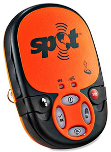
1. Friends and family can follow our tracks online as we take part in outdoor adventures and,

2. We can request help either through a pre-configured help message to a friend list or dispatch an official SOS to 911 emergency services in the event something serious happens.

EMERGENCY COMMUNICATION

It wasn’t long ago that our only mechanism for such communication in remote mountain areas was done with an amateur radio (ham radio).  Cell phone coverage is generally spotty and not something you would count on.  Ham radio coverage is a little better.  It just depends on how quickly someone would hear your distress calls over the air.  With a SPOT messenger, you only need to press a button to dispatch whichever resources you decide are necessary for the situation at hand (friends or EMTs).

REMOTE TRACKING

As for seeing real-time tracks on a map, we were doing this with the Automatic Packet/Position Reporting System (APRS) from a GPS connected to a special ham radio.  I had a Kenwood TH-D7 handheld with a Terminal Node Controller (TNC) that allowed 1200/9600bps packet communications.  When connected to my Garmin eTrex GPS, this combination transmitted coordinates over digipeters that got picked up by APRS through IGates.  I’ve done many-a-trip using this gear and related infrastructure, for both adventure-related activities and other.  It’s been a fun setup to play with but the SPOT sure has made this a lot easier!

SPOT vs. APRS

Here’s my short list of pros and cons for each.  The advantage with APRS is that the tracking “service” is free – data is just passed across the open airwaves.  The downside is that it’s a little complicated with multiple components (ham radio, GPS, specialized cable), battery management of two devices, still subject to signal strength and coverage issues with local digipeters, as well as amateur radio operation requiring a license.  The advantage with a SPOT is excellent coverage via satellite, immediate access to help at the push of a button, not to mention a compact, simple, single device that does not require a license nor any technical knowledge whatsoever.  However, the downside is the annual subscription for real-time tracking, no two-way communication capability and an opportunity for abuse (don’t send out an SOS to deliver an ice pack for your twisted ankle because you’re 20 miles from the trailhead!).

I can wait to get out and start using my cool new SPOT satellite messenger!

I Think the SPOT App is Lost →

Leave a Reply Cancel reply

Your email address will not be published. Required fields are marked *

I really wanted to do the loop, so I took another shot at Kessler, this time from the Relsek Trail. Let me tell ya, 2,000 feet of elevation in that 1-mile stretch from road to ridge is a real thigh-burner! 🥵

I also much rather liked climbing UP the gully to the summit, rather than the thought of going DOWN it (the part I didn`t want to tackle by myself last week).

As always, it felt rewarding to get it done and now I can say I`ve closed the loop on this one! 🥾⛰️

#kesslerpeak #relsektrail #loophike #wasatchmountains #legday

22 1
Open post by backcountryfever with ID 18093421613420388
I really wanted to do the loop, so I took another shot at Kessler, this time from the Relsek Trail.  Let me tell ya, 2,000 feet of elevation in that 1-mile stretch from road to ridge is a real thigh-burner! 🥵

I also much rather liked climbing UP the gully to the summit, rather than the thought of going DOWN it (the part I didn't want to tackle by myself last week).

As always, it felt rewarding to get it done and now I can say I've closed the loop on this one! 🥾⛰️

#kesslerpeak #relsektrail #loophike #wasatchmountains #legday

Today`s sufferfest on Kessler Peak!

I wanted to do the loop, but when I considered the options down off the south ridge, I decided not to try that alone. Same with the mine I saw up there... not sure if that`s the same one I`ve seen others inside a tunnel?

Still a good time after not being out in a while.

#kesslerpeak #kesslerpealtrail #wasatchfront #sufferfest #legday

20 1
Open post by backcountryfever with ID 17960032346983601
Today's sufferfest on Kessler Peak!

I wanted to do the loop, but when I considered the options down off the south ridge, I decided not to try that alone.  Same with the mine I saw up there... not sure if that's the same one I've seen others inside a tunnel? 

Still a good time after not being out in a while.

#kesslerpeak #kesslerpealtrail #wasatchfront #sufferfest #legday

I struck out on Leatherman in 2024, and added that to my list of unfinished business. With the help of some adventurous friends, we dropped it in the bag. The last 2,000 feet was grueling, but so worth it now that we`re done. Thanks Andee, Greg and Dave 👊 I wouldn`t have made it without you!

#leathermanpeak #hikeidaho #lostriverrange #peakbagging #peakbagger

23 0
Open post by backcountryfever with ID 18446485450137775
I struck out on Leatherman in 2024, and added that to my list of unfinished business.  With the help of some adventurous friends, we dropped it in the bag.  The last 2,000 feet was grueling, but so worth it now that we're done. Thanks Andee, Greg and Dave 👊 I wouldn't have made it without you!

#leathermanpeak #hikeidaho #lostriverrange #peakbagging #peakbagger

Couldn`t have asked for a better day to climb Mount Adams. The conditions today (6/4) were absolutely perfect!

These 6 miles were waaaay different from the last six I did in LA. This 6-mile climb to the summit packed in 6,700 feet of elevation and took 6 hours 45 minutes (one-way).

#mtadams #mountadams #pnw #mountaineering #legday

45 4
Open post by backcountryfever with ID 17988770517003932
Couldn't have asked for a better day to climb Mount Adams. The conditions today (6/4) were absolutely perfect!

These 6 miles were waaaay different from the last six I did in LA. This 6-mile climb to the summit packed in 6,700 feet of elevation and took 6 hours 45 minutes (one-way).

#mtadams #mountadams #pnw #mountaineering #legday

Spent the weekend in California for a wedding and managed to squeeze in a quick hike, L.A.-style.

After reaching Mount Lee behind the Hollywood Sign, I couldn`t resist tagging two other peaks along the Aileen Getty Ridge Trail: Cahuenga Peak, the highest point in Griffith Park, and Burbank Peak, home to the famous Wisdom Tree.

The hike came in at 6 miles with just 1,000 feet of elevation gain and took only 2 hours.

#hollywoodsign #cahuengapeak #burbankpeak #aileengettyridgetrail #hikela

19 0
Open post by backcountryfever with ID 17874758856610450
Spent the weekend in California for a wedding and managed to squeeze in a quick hike, L.A.-style.

After reaching Mount Lee behind the Hollywood Sign, I couldn't resist tagging two other peaks along the Aileen Getty Ridge Trail: Cahuenga Peak, the highest point in Griffith Park, and Burbank Peak, home to the famous Wisdom Tree.

The hike came in at 6 miles with just 1,000 feet of elevation gain and took only 2 hours.

#hollywoodsign #cahuengapeak #burbankpeak #aileengettyridgetrail #hikela

Still chasing snow! Took my brother-in-law on his first-ever mountaineering experience. We went up Temple Couloir, over to Deseret Peak, and then slid down West Twin Couloir. Hard to beat spring days like this.

This was my 6th summit of Deseret Peak.

#deseretpeak #templecouloir #twincouloirs #mountaineering #chasingsnow

46 4
Open post by backcountryfever with ID 17898155133454122
Still chasing snow! Took my brother-in-law on his first-ever mountaineering experience. We went up Temple Couloir, over to Deseret Peak, and then slid down West Twin Couloir.  Hard to beat spring days like this.

This was my 6th summit of Deseret Peak.

#deseretpeak #templecouloir #twincouloirs #mountaineering #chasingsnow

One of my favorite things to do between ski season and hiking season: kicking steps up a steep slope toward some snow-capped summit!

#mountaineering #kickingsteps #steepslope #snowcapped #summitday

33 4
Open post by backcountryfever with ID 17939009859229790
One of my favorite things to do between ski season and hiking season: kicking steps up a steep slope toward some snow-capped summit!

#mountaineering #kickingsteps #steepslope #snowcapped #summitday

Another moderate day of mountaineering up the north slope of Mt. Superior, known as Cardiac Bowl. I`ve only been to this peak once before, from the typical summer trail, so it was way fun to get there from this direction.

#mountsuperior #northslope #cardiacbowl #mountaineering #wasatch11ers

32 0
Open post by backcountryfever with ID 18131016616566455
Another moderate day of mountaineering up the north slope of Mt. Superior, known as Cardiac Bowl.  I've only been to this peak once before, from the typical summer trail, so it was way fun to get there from this direction.

#mountsuperior #northslope #cardiacbowl #mountaineering #wasatch11ers

With such good coverage and a big storm rolling in, I think Alta should stay open for at least another week!

#stillskiing #springskiing #skiutah #skiing #alta

15 0
Open post by backcountryfever with ID 18013199525845115
With such good coverage and a big storm rolling in, I think Alta should stay open for at least another week! 

#stillskiing #springskiing #skiutah #skiing #alta
Follow on Instagram

Recent Posts

  • Adventuring Alone on Adams
  • A Road Trip to Trout Lake
  • The Interview That Made Me Reconsider Hydrogen Water
  • After a Year with the COROS Vertix 2S
  • 5 Million Vertical Feet Gained Over 5 Years

Recent Comments

  • Kirsto on How I Would Do Kings Peak in 1 Day
  • Backcountry Fever on Solo Summit of Shasta
  • Michelle Tirhi on Solo Summit of Shasta
  • Matt on How I Would Do Kings Peak in 1 Day
  • Rich Meziere on Bummed Out By A Broken BOA Binding

RECOMMENDED READING

Categories

  • 14ers
  • Adventure Plans
  • Avalanche Awareness
  • Backpacking
  • Epic Treks
  • Grand Canyon
  • Health & Wellness
  • International Expeditions
  • Mountaineering
  • New England
  • Pacific Northwest
  • Peak Bagging
  • Product Feedback
  • Reading References
  • Road Trip
  • Scrambling
  • Season Summary
  • Seven Summits
  • Six-Pack Challenge
  • Snowshoeing
  • Social Media
  • State Highpoints
  • Technology
  • Uinta Mountains
  • Uncategorized
  • Uphill Training
  • Wasatch Front
  • Zion
©2026 Backcountry Fever