Skip to content
Menu
Backcountry Fever
  • Projects
    • Adirondack 46ers
    • Colorado 14ers
    • Seven Summits
      • Climb Aconcagua via the 360° Traverse | Full Guide
    • Wasatch 7
    • Wasatch 11ers
  • Highpoints
  • Experience
  • My Never-Ending List
  • Contact
Backcountry Fever
← A Road Trip to Trout Lake

Adventuring Alone on Adams

Posted on June 17, 2026June 17, 2026 by Backcountry Fever

DAY 3: Mount Adams South Climb Route

Thursday morning started early with breakfast at 3a and a departure from my base camp in Trout Lake around 3:30.  The drive would take about 45 minutes with time built in for a last-minute bathroom break along the way.  My goal was to be on the trail by 4:30, just like I had done on Shasta.

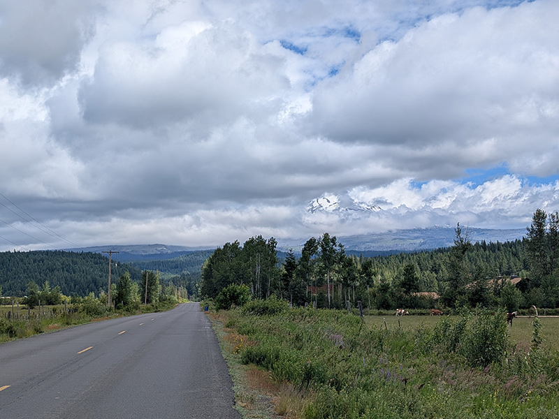
As I drove toward the trailhead, the conditions already looked fantastic.

fantastic morning conditions on adams

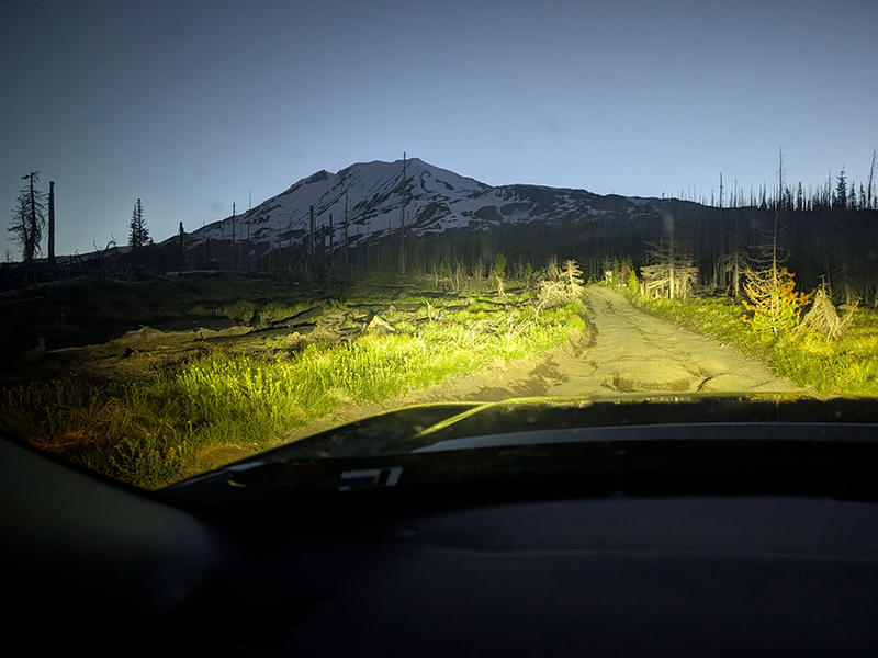
There were lots of cars at the trailhead today and plenty of people gearing up to start their adventure.  I was relieved to see that I wouldn’t be all alone on the mountain, even though I would be climbing by myself.  At 4:35am, I set off on my own adventure.

By 5:26, I had covered the first 2 miles, which was a nice warm-up with only 1,000 feet of elevation gain.

mt adams elevation profile at mile 2

I wanted to pace myself, knowing full well that this climb involved twice the elevation gain of a typical day in the mountains back home.

south climb trail at mile 2

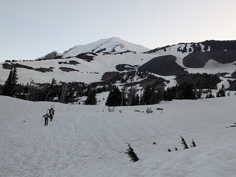
Not long after, I caught up with a group of skiers making their way up.

skiers ahead

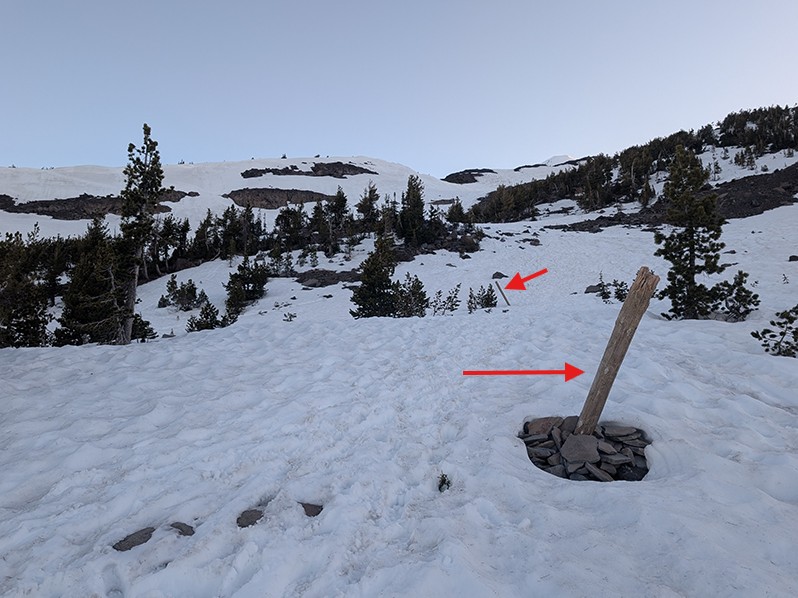
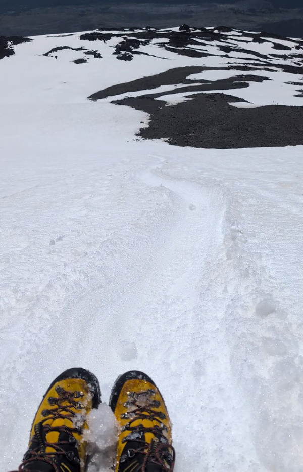
The route was easy to follow once I noticed these wooden posts marking the way.  There were plenty of tracks to follow as well, including fresh ones from climbers ahead of me.

south climb trail marker

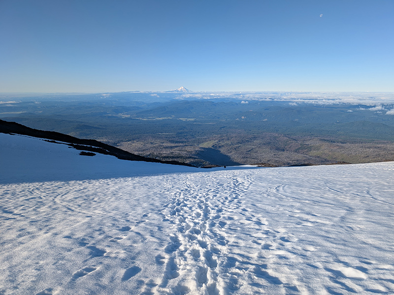
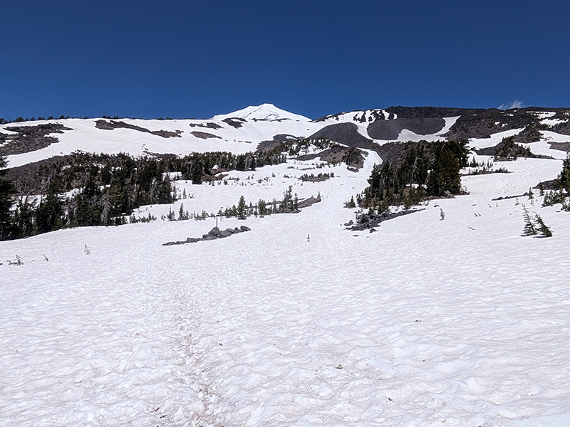
The views were incredible, with Mount St. Helens to the west…

view of mt st helens to the west

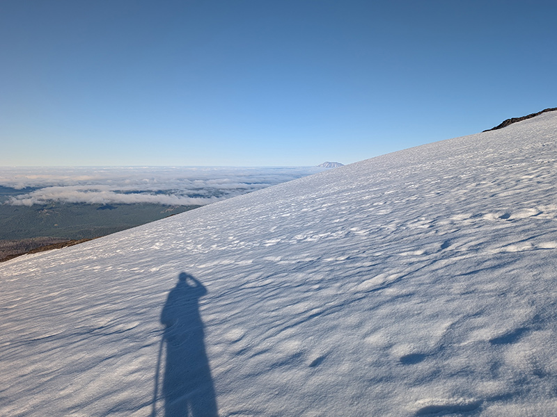
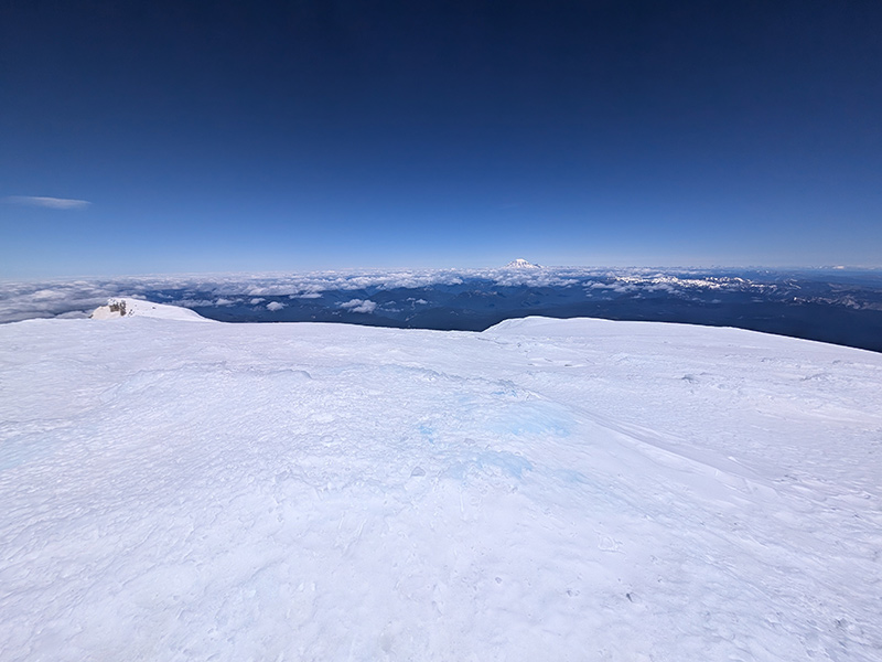
…and Mount Hood to the south.

view of mt hood to the south

By this point, I had passed three younger guys and a couple with a dog.  I was three and a half miles up the mountain and still following tracks.

approaching lunch counter

About a tenth mile later, still below Lunch Counter, the tracks I followed stayed to the right of some rocky outcroppings.  When I turned to see whether those behind me would follow, they didn’t.  Instead, they headed left.

I wondered if they knew something I didn’t, but stayed my course toward the waypoint I had marked for Lunch Counter.  That turned out to be a great decision, as I will explain here shortly.
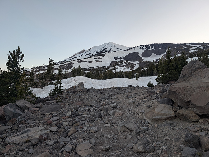
Lunch Counter

I took a quick break at Lunch Counter, where it was easy to see why this is such a popular camp area for climbers turning this ascent into a two-day adventure.

camp are at lunch counter

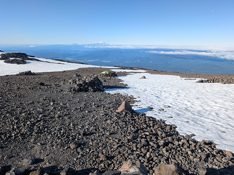
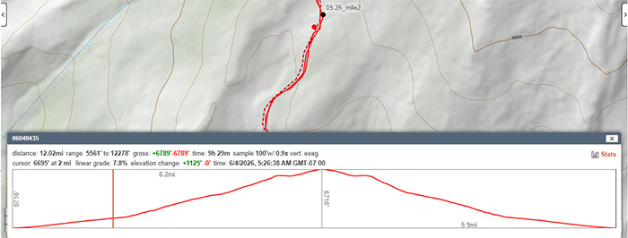
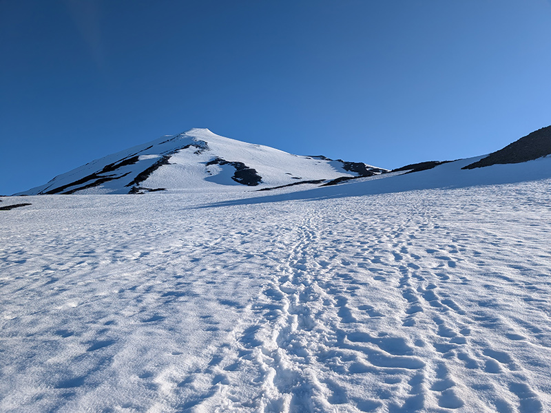
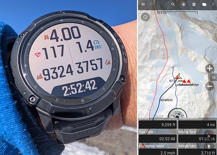
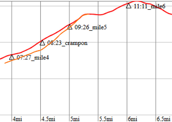
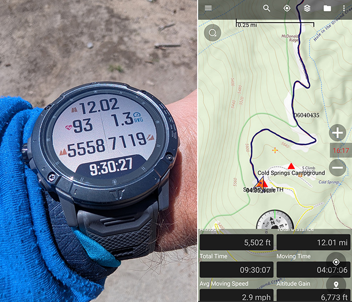
Four miles in, I was feeling great and making good time, with nearly three hours on the trail so far.  My COROS showed an elevation gain of 3,757 feet, not far off from what my phone was tracking.

mile 4 stats

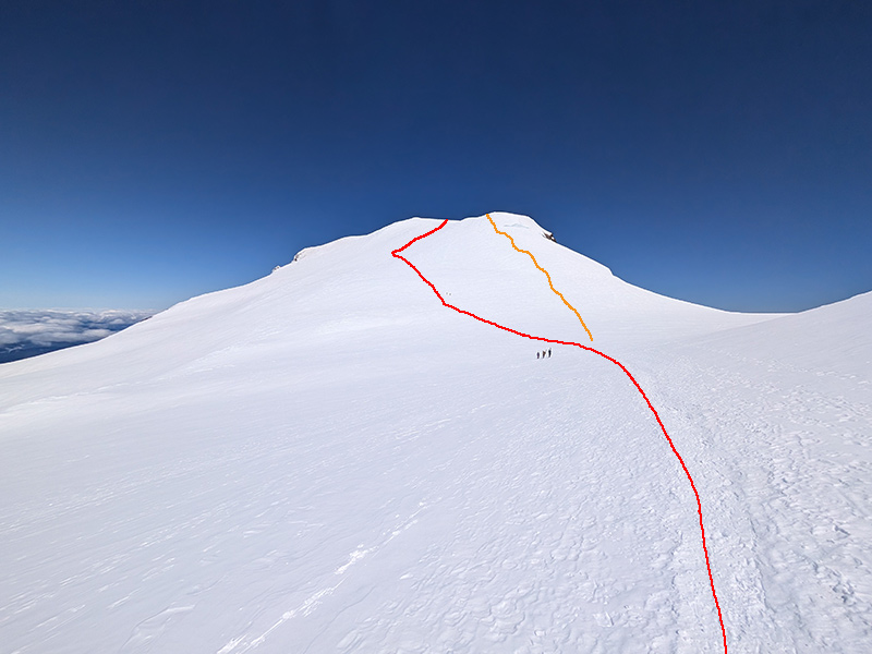
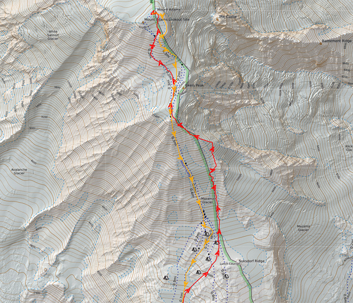
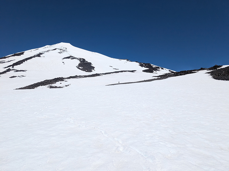
On the slope above Lunch Counter (not sure if it has a specific name), I noticed several people moving up the left-hand side, following the orange line pictured below.  Watching those black specks move ever so slowly, my focus shifted to a more gradual-looking grade off to the right, shown by the red line below.

slope above lunch counter

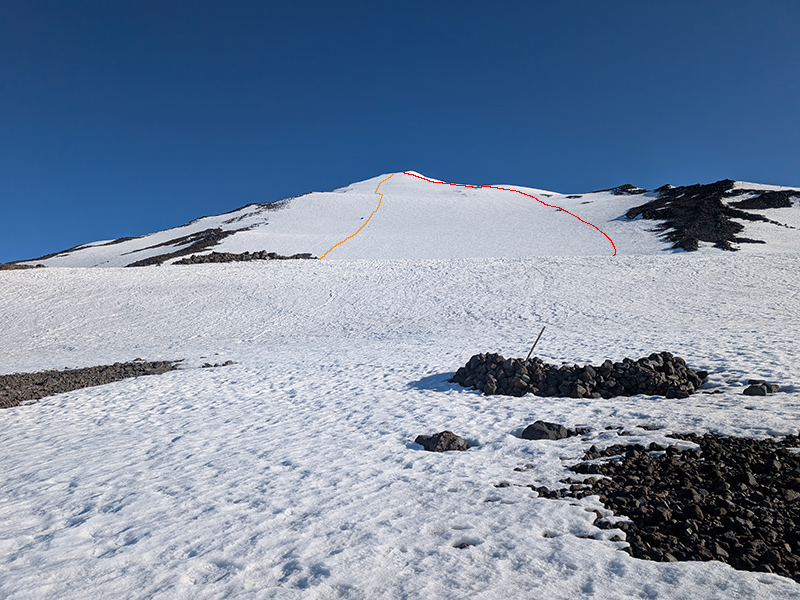
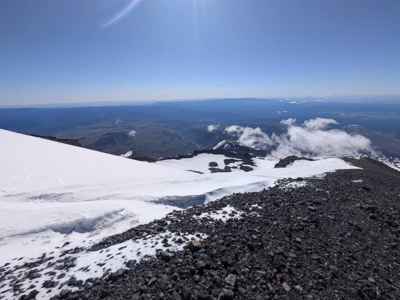
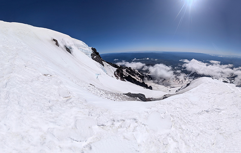
I continued to favor the right-hand side of the route, feeling compelled to find my own way.  That choice paid off because once I reached Suksdorf Ridge, I was treated to views of the Klickitat Glacier and Big Muddy Creek to the east.

big muddy creek

Those who stayed on the main route missed out.

upper klickitat glacier

As I neared the top of the false summit, the slope above Lunch Counter came back into view.  I counted fifteen people below me, still slogging up what looked to me like a staircase.  It was noticeably steeper than the “ramp” I had taken (red line).  My little detour unknowingly put me well ahead of the group.

I descended the main route (orange line) and later confirmed the difference in steepness using the elevation profile below.  Not that I needed the confirmation, but readers of this post might.

route slope comparison

Summit Push

The final push from the false summit to the top is slightly less than a mile.

above the false summit

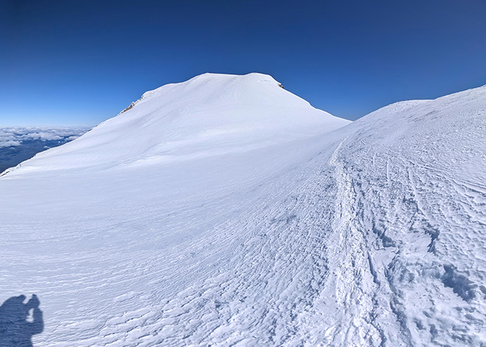
Roughly a third of that distance crosses a relatively flat area before the last half mile to the crater.  I watched a group head straight up another staircase (orange), while I once again chose the more gradual ramp (red).

summit routes

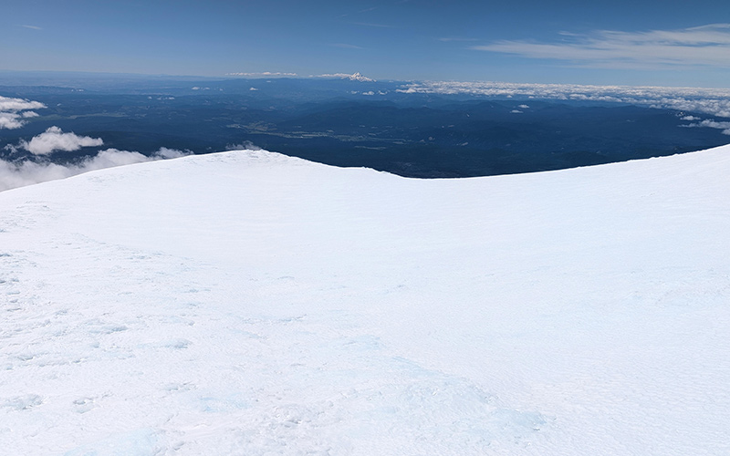
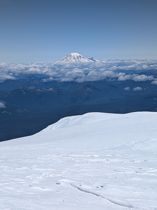
Capped in blue ice, the summit offered a clear view of Mount Rainier to the north.

mt adams summit block

I was thrilled to have reached the summit in under seven hours.

summit stats

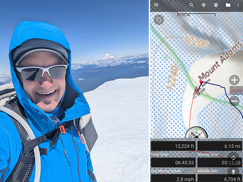
This climb covered 6.15 miles and 6,704 feet of elevation gain in just 6h 45m.  That wasn’t too far off from my stats on Shasta: 5.18 miles, 7,130 feet of elevation, and a summit time of 7h 17m.

The Descent

The crater on Mount Adams isn’t anything like the ones on South Sister or even Mount Rainier, but I did walk along its eastern rim as I started my descent.

crater rim

Unlike my ascent (red), I followed the steeper route (orange) for the descent.

map routes

The most intense part of the day was the glissade.  The first part from the false summit was so steep and icy, I had to self-arrest twice.  The snow got softer the closer I got to Lunch Counter.  It was fun after that point.

glissading down

The day turned out to be absolutely perfect.

perfect day

Nothing like the day before.  And the forecast for tomorrow wasn’t looking very good either, with an afternoon storm expected to roll in.

ideal conditions

Final stats for the day: 12 miles, 6,773 feet, 9h 30m.  (I’m not sure how my watch picked up an extra 300 feet!)

final stats map

The night ended exactly as planned: shower, pizza, Olipop, hockey, bed.

DAY 4: Return Home

When I left the next morning to begin the drive home, clouds had moved in and covered the mountain.

cloud cover on adams

I really lucked out with the timing of this trip.

← A Road Trip to Trout Lake

Leave a Reply Cancel reply

Your email address will not be published. Required fields are marked *

Couldn`t have asked for a better day to climb Mount Adams. The conditions today (6/4) were absolutely perfect!

These 6 miles were waaaay different from the last six I did in LA. This 6-mile climb to the summit packed in 6,700 feet of elevation and took 6 hours 45 minutes (one-way).

#mtadams #mountadams #pnw #mountaineering #legday

43 5
Open post by backcountryfever with ID 17988770517003932
Couldn't have asked for a better day to climb Mount Adams. The conditions today (6/4) were absolutely perfect!

These 6 miles were waaaay different from the last six I did in LA. This 6-mile climb to the summit packed in 6,700 feet of elevation and took 6 hours 45 minutes (one-way).

#mtadams #mountadams #pnw #mountaineering #legday

Spent the weekend in California for a wedding and managed to squeeze in a quick hike, L.A.-style.

After reaching Mount Lee behind the Hollywood Sign, I couldn`t resist tagging two other peaks along the Aileen Getty Ridge Trail: Cahuenga Peak, the highest point in Griffith Park, and Burbank Peak, home to the famous Wisdom Tree.

The hike came in at 6 miles with just 1,000 feet of elevation gain and took only 2 hours.

#hollywoodsign #cahuengapeak #burbankpeak #aileengettyridgetrail #hikela

19 0
Open post by backcountryfever with ID 17874758856610450
Spent the weekend in California for a wedding and managed to squeeze in a quick hike, L.A.-style.

After reaching Mount Lee behind the Hollywood Sign, I couldn't resist tagging two other peaks along the Aileen Getty Ridge Trail: Cahuenga Peak, the highest point in Griffith Park, and Burbank Peak, home to the famous Wisdom Tree.

The hike came in at 6 miles with just 1,000 feet of elevation gain and took only 2 hours.

#hollywoodsign #cahuengapeak #burbankpeak #aileengettyridgetrail #hikela

Still chasing snow! Took my brother-in-law on his first-ever mountaineering experience. We went up Temple Couloir, over to Deseret Peak, and then slid down West Twin Couloir. Hard to beat spring days like this.

This was my 6th summit of Deseret Peak.

#deseretpeak #templecouloir #twincouloirs #mountaineering #chasingsnow

46 4
Open post by backcountryfever with ID 17898155133454122
Still chasing snow! Took my brother-in-law on his first-ever mountaineering experience. We went up Temple Couloir, over to Deseret Peak, and then slid down West Twin Couloir.  Hard to beat spring days like this.

This was my 6th summit of Deseret Peak.

#deseretpeak #templecouloir #twincouloirs #mountaineering #chasingsnow

One of my favorite things to do between ski season and hiking season: kicking steps up a steep slope toward some snow-capped summit!

#mountaineering #kickingsteps #steepslope #snowcapped #summitday

33 4
Open post by backcountryfever with ID 17939009859229790
One of my favorite things to do between ski season and hiking season: kicking steps up a steep slope toward some snow-capped summit!

#mountaineering #kickingsteps #steepslope #snowcapped #summitday

Another moderate day of mountaineering up the north slope of Mt. Superior, known as Cardiac Bowl. I`ve only been to this peak once before, from the typical summer trail, so it was way fun to get there from this direction.

#mountsuperior #northslope #cardiacbowl #mountaineering #wasatch11ers

32 0
Open post by backcountryfever with ID 18131016616566455
Another moderate day of mountaineering up the north slope of Mt. Superior, known as Cardiac Bowl.  I've only been to this peak once before, from the typical summer trail, so it was way fun to get there from this direction.

#mountsuperior #northslope #cardiacbowl #mountaineering #wasatch11ers

With such good coverage and a big storm rolling in, I think Alta should stay open for at least another week!

#stillskiing #springskiing #skiutah #skiing #alta

15 0
Open post by backcountryfever with ID 18013199525845115
With such good coverage and a big storm rolling in, I think Alta should stay open for at least another week! 

#stillskiing #springskiing #skiutah #skiing #alta

It`s been a minute since I`ve had anything other than ski boots or hockey skates on my feet this winter. Gotta switch gears before the mountaineering season melts away here in Utah!

#mountaineering #kesslerpeak #westridge #wasatchfront #timetoclimb

📷 @wasatchwidescreen

23 0
Open post by backcountryfever with ID 18073878845639559
It's been a minute since I've had anything other than ski boots or hockey skates on my feet this winter.  Gotta switch gears before the mountaineering season melts away here in Utah!

#mountaineering #kesslerpeak #westridge #wasatchfront #timetoclimb

📷 @wasatchwidescreen

On this day last year—February 18—my team and I reached the summit of Aconcagua, the tallest peak in Argentina and the highest mountain in the Western Hemisphere at 22,837 feet.

I’ve enjoyed looking back on that expedition by rereading my day-by-day trip report from our climb.

👉 Link in bio: an 18-part guide covering the entire climb, plus pre-trip planning tips and post-expedition things to see and do around Mendoza.

Whether this is your first high-altitude objective or you’re adding Aconcagua to your mountaineering résumé, the guide will help you see why I chose the 360° Traverse, how to plan for your expedition, and what to expect each day on the mountain.

#aconcagua #aconcagua360 #aconcaguaexpedition #highaltitudemountaineering #mountaineering

35 2
Open post by backcountryfever with ID 18055701743428917
On this day last year—February 18—my team and I reached the summit of Aconcagua, the tallest peak in Argentina and the highest mountain in the Western Hemisphere at 22,837 feet.

I’ve enjoyed looking back on that expedition by rereading my day-by-day trip report from our climb.

👉 Link in bio: an 18-part guide covering the entire climb, plus pre-trip planning tips and post-expedition things to see and do around Mendoza.

Whether this is your first high-altitude objective or you’re adding Aconcagua to your mountaineering résumé, the guide will help you see why I chose the 360° Traverse, how to plan for your expedition, and what to expect each day on the mountain.

#aconcagua #aconcagua360 #aconcaguaexpedition #highaltitudemountaineering #mountaineering

Winter is my favorite season, and cold weather camping is one of my favorite winter activities.

#coldweathercamping #wintercamping #tenting #lovewinter #lovecamping

19 0
Open post by backcountryfever with ID 18088708565160118
Winter is my favorite season, and cold weather camping is one of my favorite winter activities.

#coldweathercamping #wintercamping #tenting #lovewinter #lovecamping
Follow on Instagram

Recent Posts

  • Adventuring Alone on Adams
  • A Road Trip to Trout Lake
  • The Interview That Made Me Reconsider Hydrogen Water
  • After a Year with the COROS Vertix 2S
  • 5 Million Vertical Feet Gained Over 5 Years

Recent Comments

  • Backcountry Fever on Solo Summit of Shasta
  • Michelle Tirhi on Solo Summit of Shasta
  • Matt on How I Would Do Kings Peak in 1 Day
  • Rich Meziere on Bummed Out By A Broken BOA Binding
  • Backcountry Fever on Bummed Out By A Broken BOA Binding

RECOMMENDED READING

Categories

  • 14ers
  • Adventure Plans
  • Avalanche Awareness
  • Backpacking
  • Epic Treks
  • Grand Canyon
  • Health & Wellness
  • International Expeditions
  • Mountaineering
  • Pacific Northwest
  • Peak Bagging
  • Product Feedback
  • Reading References
  • Road Trip
  • Scrambling
  • Season Summary
  • Seven Summits
  • Six-Pack Challenge
  • Snowshoeing
  • Social Media
  • State Highpoints
  • Technology
  • Uinta Mountains
  • Uncategorized
  • Uphill Training
  • Wasatch Front
  • Zion
©2026 Backcountry Fever