Skip to content
Menu
Backcountry Fever
  • Projects
    • Adirondack 46ers
    • Colorado 14ers
    • Seven Summits
      • Climb Aconcagua via the 360° Traverse | Full Guide
    • Wasatch 7
    • Wasatch 11ers
  • Highpoints
  • Experience
  • My Never-Ending List
  • Contact
Backcountry Fever
← To Be, Or Not To Be… Guided, That Is
Prepping for Denali Prep with AMS →

Este Corto Paseo Hasta El Miro

Posted on February 6, 2024October 15, 2025 by Backcountry Fever

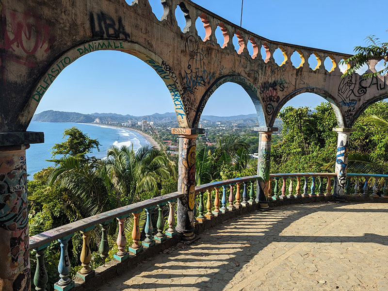
If you’re ever in Costa Rica, around the Jacó area, I would highly recommend this short walk to El Miro.  The views are beautiful!

view of jaco

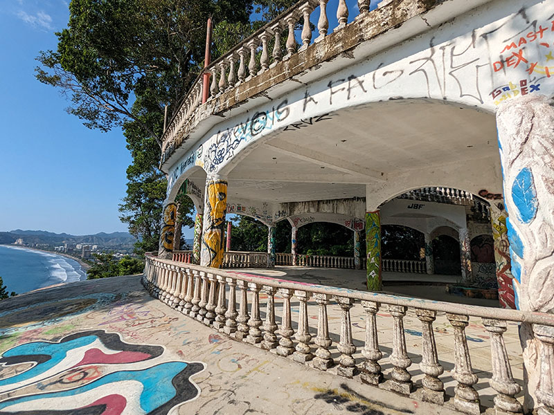
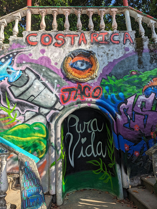
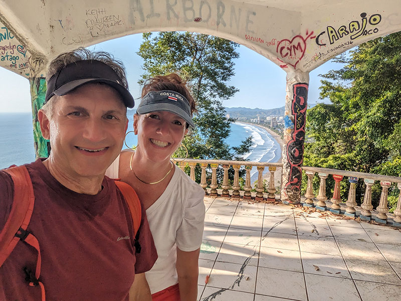
Whether this was intended to be a luxury hotel or someone’s private mansion, the location of this abandoned structure can be found at the south end of Jacó.

overview

I know very little of its backstory and only came to find out about this through a friend from Costa Rica.

abandoned mansion

He suggested a quick stop here on our way down to Manuel Antonio for the week.

top floor

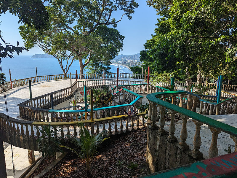
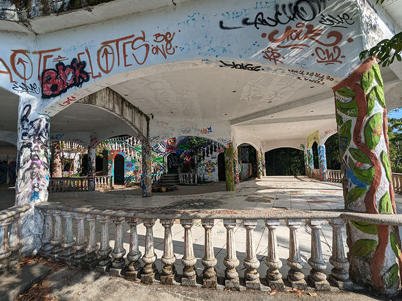
Whether you view this as art or graffiti, we found it very colorful and something of interest to see.

grafitti art

How to Find El Miro

Finding El Miro can be a bit tricky though.  It does show a valid location on Google Maps, but relying on Google only gets you close.

google maps

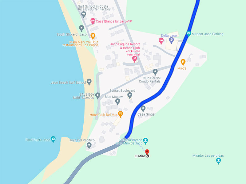
Here are better directions to help.  Start by navigating to Delta Jacó, a gas station right off Route 34 near Jacó’s south shores.

delta jaco

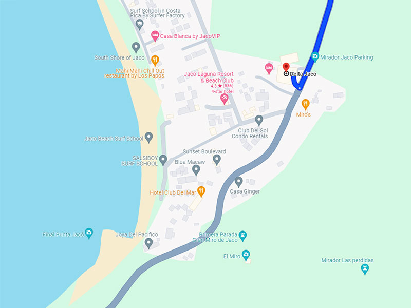
Immediately across from this gas station is one option for parking.  A friendly local charged us 2,000 colones (about 4US dollars) to park our car there.  The walk starts just a few yards south of this location.

trail map

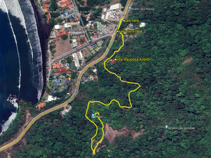
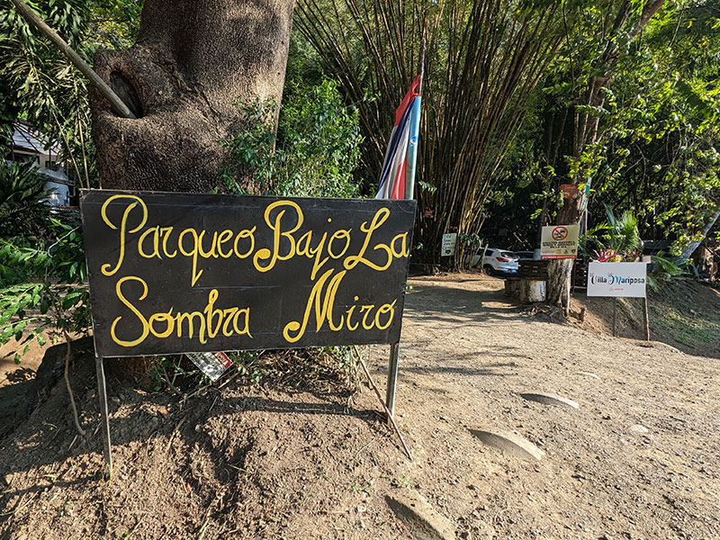
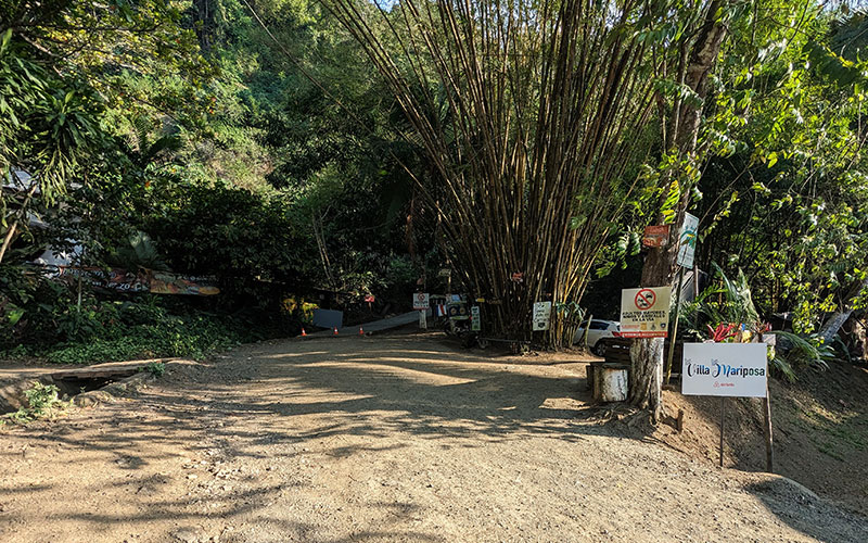
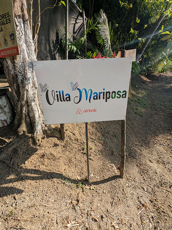
You know you’re in the right place if these signs are still there.  The big one is offering shaded parking while the smaller white one on the far right indicates the driveway for an Airbnb called Villa Mariposa.

el miro sign

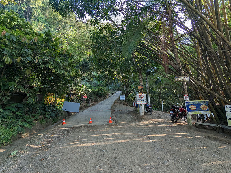
Turn in and head for the cones across the pavement.

starts here

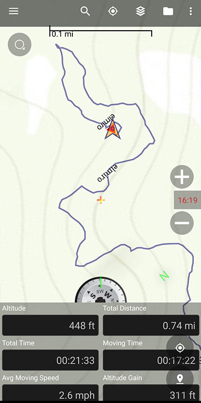
From this point on, it’s just a short walk…  it starts out paved for a short stretch and then turns to dirt.  The whole trail up is less than a mile with only 300 feet of elevation.

short walk up

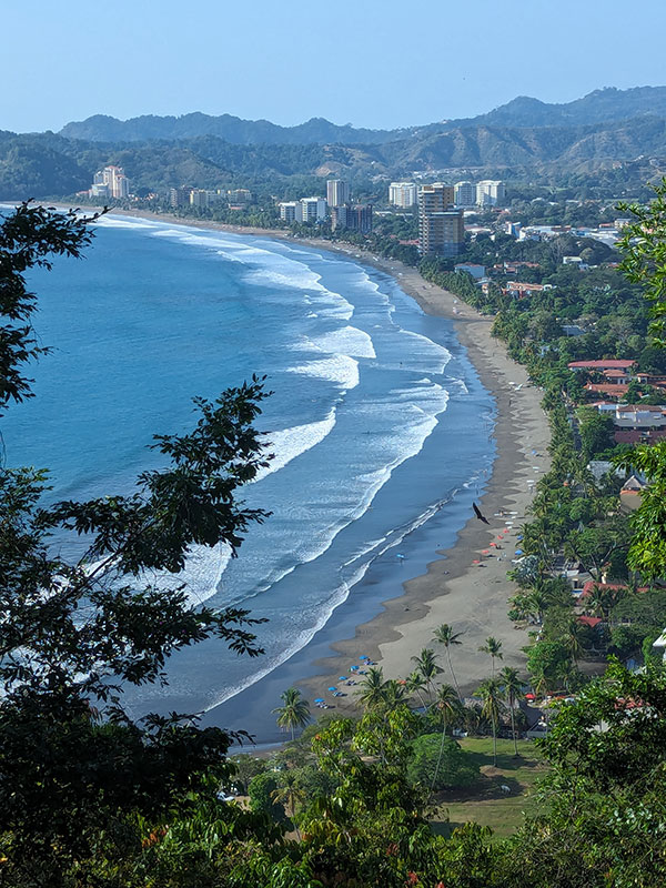
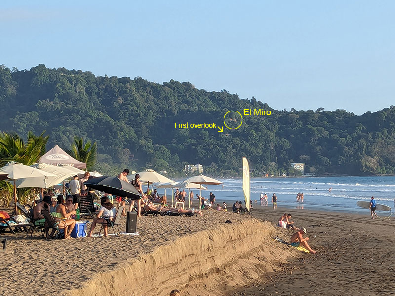
The first viewpoint is about a 1/2 mile in.

first viewpoint

Keep going another 1/4 mile to the main building.  If you’re in no rush, it should take you 20-ish minutes.

fun stop

I bet watching the sunset from here would be awesome!

ocean view

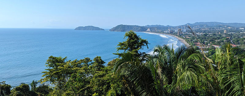
If you do end up somewhere along Jacó’s beachfront, look for El Miro over on the hillside.

view from jaco

After we got home, I found the trail clearly marked on this CalTopo map.  It even looks like you can reach El Miro from the other side using the Calle Miro trail?  I just don’t know what the road conditions are like along Calle Cerro Fresco.  If you end up exploring this more, let me know what you found!


← To Be, Or Not To Be… Guided, That Is
Prepping for Denali Prep with AMS →

Leave a Reply Cancel reply

Your email address will not be published. Required fields are marked *

Couldn`t have asked for a better day to climb Mount Adams. The conditions today (6/4) were absolutely perfect!

These 6 miles were waaaay different from the last six I did in LA. This 6-mile climb to the summit packed in 6,700 feet of elevation and took 6 hours 45 minutes (one-way).

#mtadams #mountadams #pnw #mountaineering #legday

43 4
Open post by backcountryfever with ID 17988770517003932
Couldn't have asked for a better day to climb Mount Adams. The conditions today (6/4) were absolutely perfect!

These 6 miles were waaaay different from the last six I did in LA. This 6-mile climb to the summit packed in 6,700 feet of elevation and took 6 hours 45 minutes (one-way).

#mtadams #mountadams #pnw #mountaineering #legday

Spent the weekend in California for a wedding and managed to squeeze in a quick hike, L.A.-style.

After reaching Mount Lee behind the Hollywood Sign, I couldn`t resist tagging two other peaks along the Aileen Getty Ridge Trail: Cahuenga Peak, the highest point in Griffith Park, and Burbank Peak, home to the famous Wisdom Tree.

The hike came in at 6 miles with just 1,000 feet of elevation gain and took only 2 hours.

#hollywoodsign #cahuengapeak #burbankpeak #aileengettyridgetrail #hikela

18 0
Open post by backcountryfever with ID 17874758856610450
Spent the weekend in California for a wedding and managed to squeeze in a quick hike, L.A.-style.

After reaching Mount Lee behind the Hollywood Sign, I couldn't resist tagging two other peaks along the Aileen Getty Ridge Trail: Cahuenga Peak, the highest point in Griffith Park, and Burbank Peak, home to the famous Wisdom Tree.

The hike came in at 6 miles with just 1,000 feet of elevation gain and took only 2 hours.

#hollywoodsign #cahuengapeak #burbankpeak #aileengettyridgetrail #hikela

Still chasing snow! Took my brother-in-law on his first-ever mountaineering experience. We went up Temple Couloir, over to Deseret Peak, and then slid down West Twin Couloir. Hard to beat spring days like this.

This was my 6th summit of Deseret Peak.

#deseretpeak #templecouloir #twincouloirs #mountaineering #chasingsnow

46 4
Open post by backcountryfever with ID 17898155133454122
Still chasing snow! Took my brother-in-law on his first-ever mountaineering experience. We went up Temple Couloir, over to Deseret Peak, and then slid down West Twin Couloir.  Hard to beat spring days like this.

This was my 6th summit of Deseret Peak.

#deseretpeak #templecouloir #twincouloirs #mountaineering #chasingsnow

One of my favorite things to do between ski season and hiking season: kicking steps up a steep slope toward some snow-capped summit!

#mountaineering #kickingsteps #steepslope #snowcapped #summitday

33 4
Open post by backcountryfever with ID 17939009859229790
One of my favorite things to do between ski season and hiking season: kicking steps up a steep slope toward some snow-capped summit!

#mountaineering #kickingsteps #steepslope #snowcapped #summitday

Another moderate day of mountaineering up the north slope of Mt. Superior, known as Cardiac Bowl. I`ve only been to this peak once before, from the typical summer trail, so it was way fun to get there from this direction.

#mountsuperior #northslope #cardiacbowl #mountaineering #wasatch11ers

32 0
Open post by backcountryfever with ID 18131016616566455
Another moderate day of mountaineering up the north slope of Mt. Superior, known as Cardiac Bowl.  I've only been to this peak once before, from the typical summer trail, so it was way fun to get there from this direction.

#mountsuperior #northslope #cardiacbowl #mountaineering #wasatch11ers

With such good coverage and a big storm rolling in, I think Alta should stay open for at least another week!

#stillskiing #springskiing #skiutah #skiing #alta

15 0
Open post by backcountryfever with ID 18013199525845115
With such good coverage and a big storm rolling in, I think Alta should stay open for at least another week! 

#stillskiing #springskiing #skiutah #skiing #alta

It`s been a minute since I`ve had anything other than ski boots or hockey skates on my feet this winter. Gotta switch gears before the mountaineering season melts away here in Utah!

#mountaineering #kesslerpeak #westridge #wasatchfront #timetoclimb

📷 @wasatchwidescreen

23 0
Open post by backcountryfever with ID 18073878845639559
It's been a minute since I've had anything other than ski boots or hockey skates on my feet this winter.  Gotta switch gears before the mountaineering season melts away here in Utah!

#mountaineering #kesslerpeak #westridge #wasatchfront #timetoclimb

📷 @wasatchwidescreen

On this day last year—February 18—my team and I reached the summit of Aconcagua, the tallest peak in Argentina and the highest mountain in the Western Hemisphere at 22,837 feet.

I’ve enjoyed looking back on that expedition by rereading my day-by-day trip report from our climb.

👉 Link in bio: an 18-part guide covering the entire climb, plus pre-trip planning tips and post-expedition things to see and do around Mendoza.

Whether this is your first high-altitude objective or you’re adding Aconcagua to your mountaineering résumé, the guide will help you see why I chose the 360° Traverse, how to plan for your expedition, and what to expect each day on the mountain.

#aconcagua #aconcagua360 #aconcaguaexpedition #highaltitudemountaineering #mountaineering

34 2
Open post by backcountryfever with ID 18055701743428917
On this day last year—February 18—my team and I reached the summit of Aconcagua, the tallest peak in Argentina and the highest mountain in the Western Hemisphere at 22,837 feet.

I’ve enjoyed looking back on that expedition by rereading my day-by-day trip report from our climb.

👉 Link in bio: an 18-part guide covering the entire climb, plus pre-trip planning tips and post-expedition things to see and do around Mendoza.

Whether this is your first high-altitude objective or you’re adding Aconcagua to your mountaineering résumé, the guide will help you see why I chose the 360° Traverse, how to plan for your expedition, and what to expect each day on the mountain.

#aconcagua #aconcagua360 #aconcaguaexpedition #highaltitudemountaineering #mountaineering

Winter is my favorite season, and cold weather camping is one of my favorite winter activities.

#coldweathercamping #wintercamping #tenting #lovewinter #lovecamping

19 0
Open post by backcountryfever with ID 18088708565160118
Winter is my favorite season, and cold weather camping is one of my favorite winter activities.

#coldweathercamping #wintercamping #tenting #lovewinter #lovecamping
Follow on Instagram

Recent Posts

  • The Interview That Made Me Reconsider Hydrogen Water
  • After a Year with the COROS Vertix 2S
  • 5 Million Vertical Feet Gained Over 5 Years
  • 2025 Year in Review
  • From Waikīkī to Makapuʻu: A Casual Tour of Honolulu Stops

Recent Comments

  • Backcountry Fever on Solo Summit of Shasta
  • Michelle Tirhi on Solo Summit of Shasta
  • Matt on How I Would Do Kings Peak in 1 Day
  • Rich Meziere on Bummed Out By A Broken BOA Binding
  • Backcountry Fever on Bummed Out By A Broken BOA Binding

RECOMMENDED READING

Categories

  • 14ers
  • Adventure Plans
  • Avalanche Awareness
  • Backpacking
  • Epic Treks
  • Grand Canyon
  • Health & Wellness
  • International Expeditions
  • Mountaineering
  • Pacific Northwest
  • Peak Bagging
  • Product Feedback
  • Reading References
  • Road Trip
  • Scrambling
  • Season Summary
  • Seven Summits
  • Six-Pack Challenge
  • Snowshoeing
  • Social Media
  • State Highpoints
  • Technology
  • Uinta Mountains
  • Uncategorized
  • Uphill Training
  • Wasatch Front
  • Zion
©2026 Backcountry Fever