Skip to content
Menu
Backcountry Fever
  • Projects
    • Adirondack 46ers
    • Colorado 14ers
    • Seven Summits
      • Climb Aconcagua via the 360° Traverse | Full Guide
    • Wasatch 7
    • Wasatch 11ers
  • Highpoints
  • Experience
  • My Never-Ending List
  • Contact
Backcountry Fever
← Are You An Athlete with Type-1 Diabetes?
How I Would Do Kings Peak in 1 Day →

Strike 1 at Leatherman Peak

Posted on July 23, 2024October 3, 2024 by Backcountry Fever

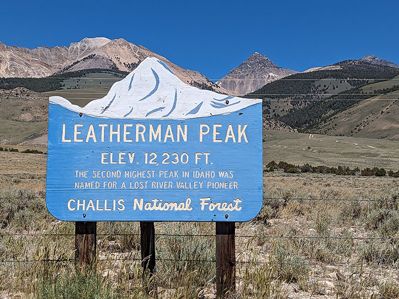
After finishing my fourth summit of Borah Peak last year, I decided to take a look-see at the trailhead for Leatherman Peak for a possible attempt this year.  It’s the 2nd tallest peak in Idaho so, why not?  I also wanted to try something new as we trekked out for the Armstrong Family Reunion in Mackay again.

Notice the clear blue skies from last years pictures compared to this year’s smoky haze from wildfires.

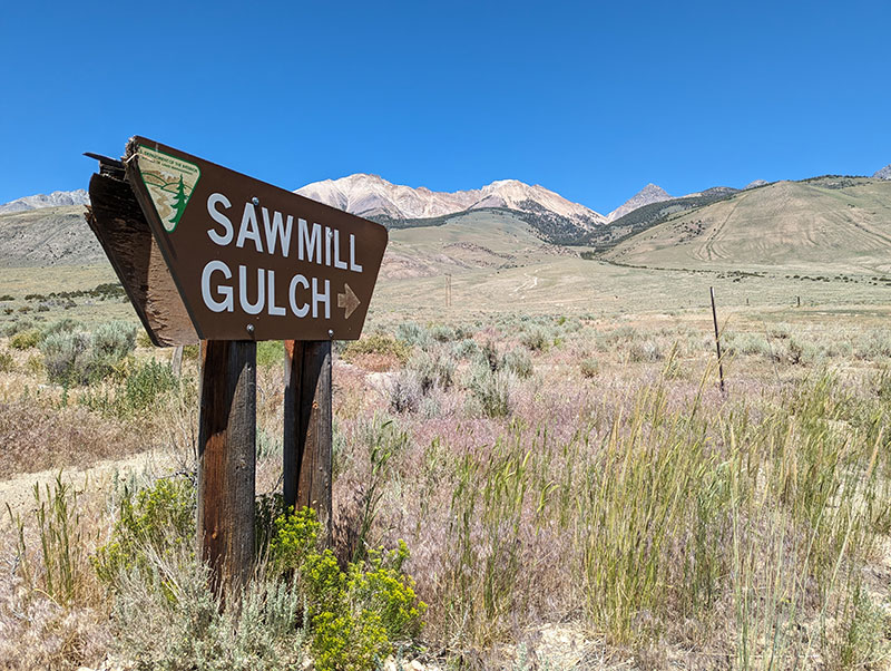
I started from Sawmill Gulch, since that was the shortest drive from Mackay.

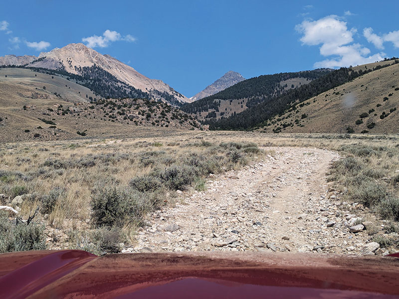
This route from the west appears to be much less popular in comparison to Borah.  It begins on a rough road that is best traveled with higher clearance vehicles.  I crawled along between 6 and 8 mph.

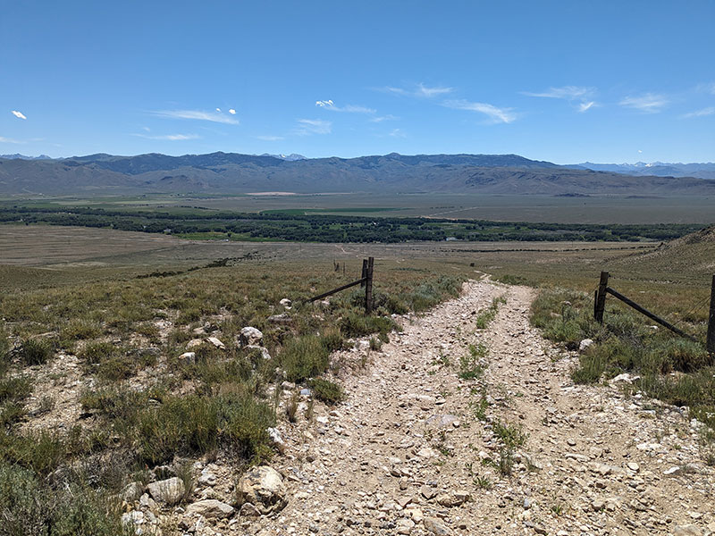
At 1.3 miles up this road, you pass through a fence opening.  This pic was taken looking back at where I just came from.

A quarter mile beyond the fence is the last “easy” place to park if your vehicle has reached its limit.  The parking area here, with only room for 3-4 cars, is right before the road narrows at an outcropping.

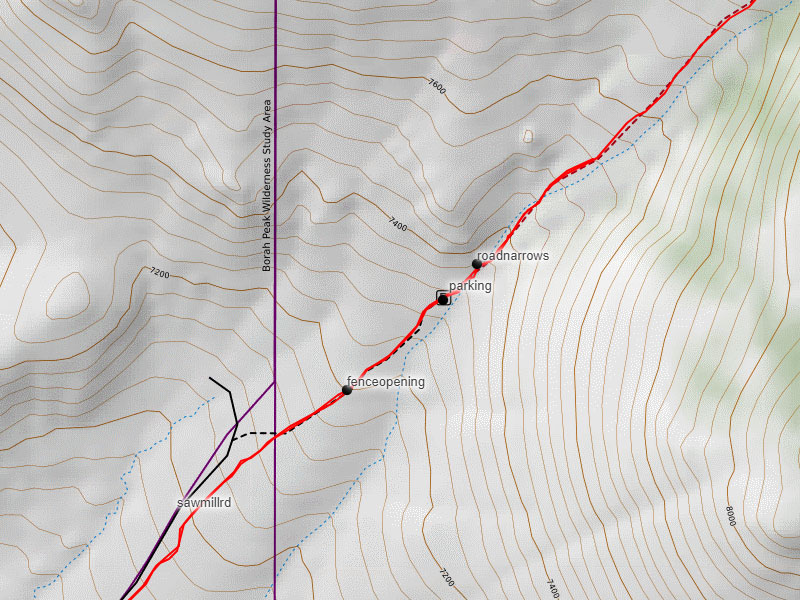
Driving a Toyota Tacoma, I pressed on.  The road definitely turned worse before it got better.  I finally called it good right before this loose rock area, 2.5 miles in.  My concern grew about finding a place wide enough to turn around as the road narrowed,  so I parked in what looked to be a primitive camp spot.

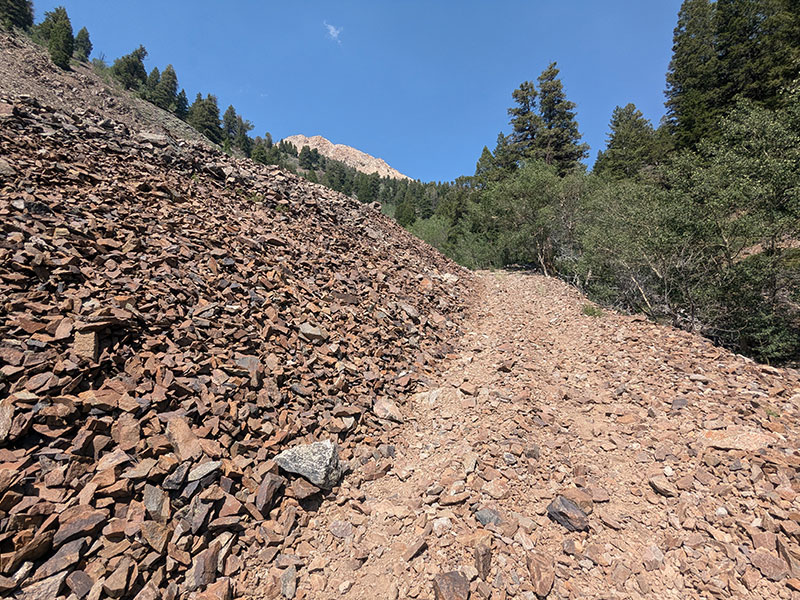
Once I started hiking, I could see my truck could have made it up another quarter mile… which is as far as you should go.  Looking back at this highest place you could park, there is plenty of room to turn a vehicle around.  Pushing beyond this point would take a serious offroad driver to navigate.

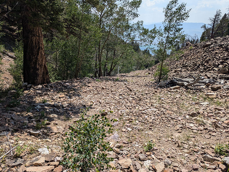
Then again, only a quarter mile above this upper parking area is a fallen tree that blocks the road.  So driving further up really doesn’t do you any good anyway.  Plus, you missed the trail if you see this tree.

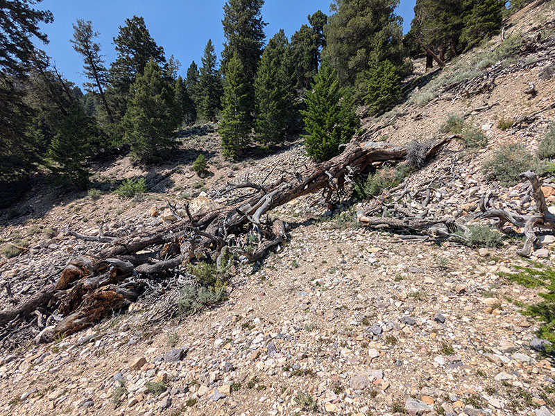
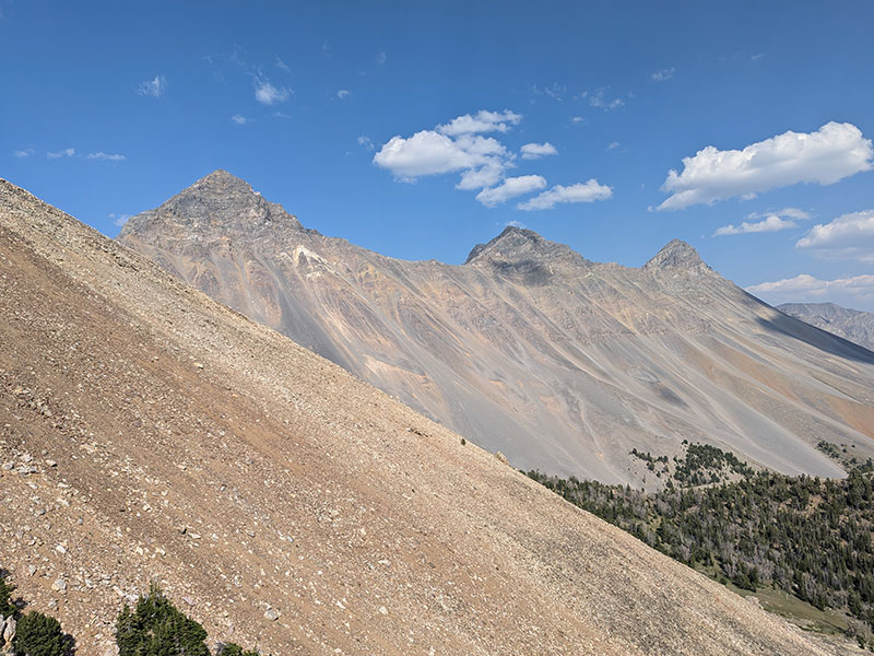
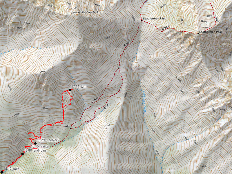
My biggest mistake was to follow the road to the end, thinking it was part of the “trail” to Leatherman Pass.  Turns out that was an incorrect assumption.  Luckily, it wasn’t more than a mile before I realized this can’t be right.  I backtracked and looked for something that followed the gulch in the direction of the pass.  When I couldn’t see anything obvious, I just did the goat worthy thing straight up this gully.

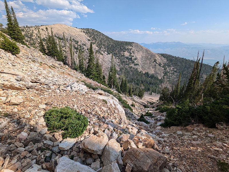
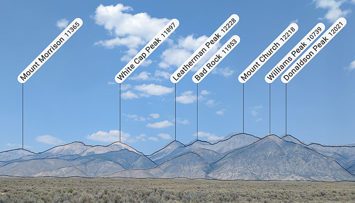
There was an Unnamed 11k peak to my left that felt more realistic and tempted me to go there instead.

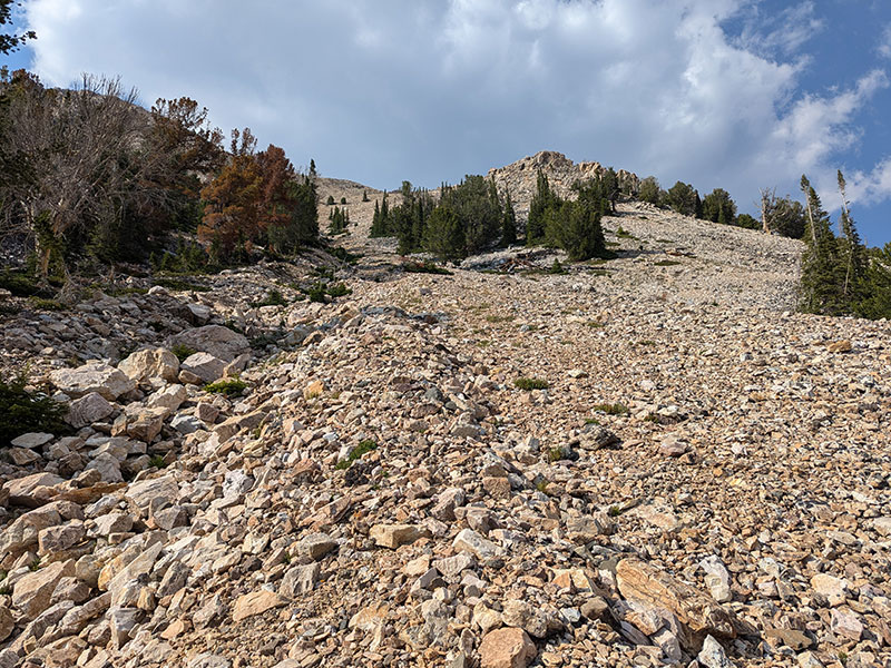
But I resisted and just kept climbing this boulder field in the general direction of Leatherman Peak.

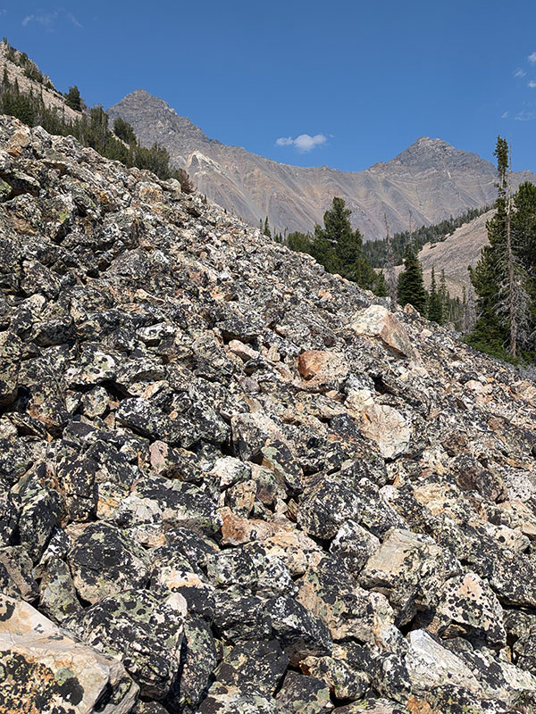
When I reached 10,000′, I could see that I had a long way to go, still off-track and running out of time.

This is where I decided it just wasn’t worth it and turned around.  I started too late, lost the trail, underestimated the time it would take and hiking alone in a less popular area.  I did locate the actual trail coming down, but didn’t see it on my digital maps.

What is disappointing was using Backcountry Navigator with CalTopo maps…

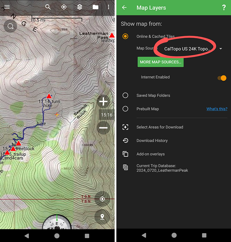
…not quite showing the same level of detail as CalTopo.com.

Oh well.  Guess it’ll have to wait for another year.

← Are You An Athlete with Type-1 Diabetes?
How I Would Do Kings Peak in 1 Day →

Leave a Reply Cancel reply

Your email address will not be published. Required fields are marked *

My first time up Mt. Ogden unintentionally turned into a full-on-loop-de-doo: up Beus, down Malan`s.

Beus Canyon was pretty boring above treeline, so I decided not to head back the way I came. After tagging the summit, I figured Malan`s would be way more interesting — and it sure was!

Malan`s Basin is surprisingly sketch up high, through a steep and narrow gully, then hard to follow in the middle where an already faint trail disappeared under leaves. I lost the trail a few times and had to backtrack a bit to find my way.

Finally, the Bonneville Shoreline Trail came in clutch once again, making this a nice long loop-de-doo.

Mt. Ogden Loop-de-doo mileage breakdown 👇
- Beus Canyon trailhead to summit, 6 miles
- Mt. Ogden to Malan`s Peak, 3 miles
- Malan`s Peak to Bonneville Shoreline Trail, 3 miles
- BST across and back to Beus trailhead, 3 miles

For a total of 15 miles and 5,300 feet of elevation gain.

#mtogden #mountogden #ogdenpeak #beuscanyon #beuscanyontrail #malansbasin #malanspeak #bonnevilleshorelinetrail #bonnevilleshoreline #bst #loophike #loopdedoo #wasatchfront #hikeogden #fallhike #fallhikingfallhiking

22 0
Open post by backcountryfever with ID 17906240730272550
My first time up Mt. Ogden unintentionally turned into a full-on-loop-de-doo: up Beus, down Malan's. 

Beus Canyon was pretty boring above treeline, so I decided not to head back the way I came. After tagging the summit, I figured Malan's would be way more interesting — and it sure was!

Malan's Basin is surprisingly sketch up high, through a steep and narrow gully, then hard to follow in the middle where an already faint trail disappeared under leaves.  I lost the trail a few times and had to backtrack a bit to find my way.

Finally, the Bonneville Shoreline Trail came in clutch once again, making this a nice long loop-de-doo.

Mt. Ogden Loop-de-doo mileage breakdown 👇
- Beus Canyon trailhead to summit, 6 miles
- Mt. Ogden to Malan's Peak, 3 miles
- Malan's Peak to Bonneville Shoreline Trail, 3 miles
- BST across and back to Beus trailhead, 3 miles

For a total of 15 miles and 5,300 feet of elevation gain.

#mtogden #mountogden #ogdenpeak #beuscanyon #beuscanyontrail #malansbasin #malanspeak #bonnevilleshorelinetrail #bonnevilleshoreline #bst #loophike #loopdedoo #wasatchfront #hikeogden #fallhike #fallhikingfallhiking

Awesome views from the top of Y Mountain. Looking north into Rock Canyon, where I started, and across towards the old Squaw Peak, Cascade Mountain, and Mount Timpanogos further off in the distance.

Pretty fun loop hike 👇

- Up 1.8 miles from the Rock Canyon trailhead
- Up 1.8 miles on First Right Fork to Slide Canyon
- Down Slide Canyon Trail .5 miles to Y Mountain Trail
- Up 1 mile to Y Mountain West Peak
- Down .25 and over .25 miles to Y Mountain East Peak
- Down 1 mile back to Slide Canyon Trail
- Down 1.5 miles to Y Trail (top of the BYU Y)
- Down 1 mile to the Y Trail trailhead
- Across 1.75 miles on the Bonneville Shoreline Trail

For a total of 10.75 miles with 4,137 feet of elevation gain.

#ymountain #rockcanyon #rockcanyontrail #firstrightfork #slidecanyon #ytrail #ytrailhead #bst #bonnevilleshorelinetrail #bonnevilleshoreline #connector #loophike #wasatchfront #hikethewasatch #wasatchmountains #wasatch #hike #hikemore

31 1
Open post by backcountryfever with ID 17900152413305912
Awesome views from the top of Y Mountain.  Looking north into Rock Canyon, where I started, and across towards the old Squaw Peak, Cascade Mountain, and Mount Timpanogos further off in the distance. 

Pretty fun loop hike 👇

- Up 1.8 miles from the Rock Canyon trailhead
- Up 1.8 miles on First Right Fork to Slide Canyon
- Down Slide Canyon Trail .5 miles to Y Mountain Trail
- Up 1 mile to Y Mountain West Peak 
- Down .25 and over .25 miles to Y Mountain East Peak
- Down 1 mile back to Slide Canyon Trail
- Down 1.5 miles to Y Trail (top of the BYU Y)
- Down 1 mile to the Y Trail trailhead
- Across 1.75 miles on the Bonneville Shoreline Trail

For a total of 10.75 miles with 4,137 feet of elevation gain.

#ymountain #rockcanyon #rockcanyontrail #firstrightfork #slidecanyon #ytrail #ytrailhead #bst #bonnevilleshorelinetrail #bonnevilleshoreline #connector #loophike #wasatchfront #hikethewasatch #wasatchmountains #wasatch #hike #hikemore

As the seasons change, each quiet mile through these trees feels like an invitation to let go of what was and move toward all that`s yet to come...

#seasonschange #lettinggo #movingon #pressingforward #lookingahead #newbeginnings #natureishealing #healingenergy #goodvibes #autumnvibes #autumnmountains #hiking #hikerlife #mountainlife #mountains

25 0
Open post by backcountryfever with ID 17902202193279047
As the seasons change, each quiet mile through these trees feels like an invitation to let go of what was and move toward all that's yet to come...

#seasonschange #lettinggo #movingon #pressingforward #lookingahead #newbeginnings #natureishealing #healingenergy #goodvibes #autumnvibes #autumnmountains #hiking #hikerlife #mountainlife #mountains

Fall colors are fading fast, losing the battle with winter.

#fallcolors #fadingfast #autumn #hikingtrails #hiking #hike #hiker #getreadyforwinter

14 0
Open post by backcountryfever with ID 17913756879229216
Fall colors are fading fast, losing the battle with winter.

#fallcolors #fadingfast #autumn #hikingtrails #hiking #hike #hiker #getreadyforwinter

I had high hopes of doing some hiking during a recent trip to O`ahu.  Unfortunately, a lower leg injury from a Summer Hockey League playoff game last month left me hobbling around just enough to make the trip, but not much else.  

This is what I was hoping to explore while spending 10 days on O`ahu for the first time.  I also knew I wouldn`t get to all of them in one trip — especially with other things we wanted to do — so here they are in order of priority:

- Backway for the Stairway to Heaven (Haiku Stairs)
- Three Peaks (Mt. Olomana)
- Reverse Olomana Trail
- Makapu`u Lighthouse Trail
- Koko Crater Stairs
- Koko Crater Rim Trail
- Diamond Head Crater Trail
- Old Pali Highway
- Mt. Ka`ala (tallest peak on O`ahu)
- Pūpūkea to La`ie
 
Maybe next time...

#hikehawaii #hawaiihiking #oahu #stairwaytoheaven #haikustairs #threepeaks #olomana #kokocrater #rimtrail #oldpalihighway #mtkaala #lowerleginjury #musclestrain #tibialisanterior #hockey

24 4
Open post by backcountryfever with ID 18403849120137976
I had high hopes of doing some hiking during a recent trip to O'ahu.  Unfortunately, a lower leg injury from a Summer Hockey League playoff game last month left me hobbling around just enough to make the trip, but not much else.   

This is what I was hoping to explore while spending 10 days on O'ahu for the first time.  I also knew I wouldn't get to all of them in one trip — especially with other things we wanted to do — so here they are in order of priority:

- Backway for the Stairway to Heaven (Haiku Stairs)
- Three Peaks (Mt. Olomana)
- Reverse Olomana Trail
- Makapu'u Lighthouse Trail
- Koko Crater Stairs
- Koko Crater Rim Trail
- Diamond Head Crater Trail
- Old Pali Highway
- Mt. Ka'ala (tallest peak on O'ahu)
- Pūpūkea to La'ie
 
Maybe next time...

#hikehawaii #hawaiihiking #oahu #stairwaytoheaven #haikustairs #threepeaks #olomana #kokocrater #rimtrail #oldpalihighway #mtkaala #lowerleginjury #musclestrain #tibialisanterior #hockey

Six months ago today, I stood on top of the tallest peak in the Americas — Aconcagua, Argentina — and it has taken me that long to finish a series of posts about my epic adventure!

This day-by-day trip report is packed with photos, route descriptions, and insights from my own experience.  You’ll find everything from what to pack, to what the camps are really like, to why I think the 360° Traverse is the ideal choice.

👉 Lnk in bio!

Whether it’s your first high-altitude climb or you’re adding Aconcagua to your mountaineering resume, the 360° Traverse offers one of the most satisfying ways to stand on the highest point in South America.

#aconcagua #climbaconcagua #aconcagua360 #360traverse #highpoint #highpointing #highestpoint #tallestpeak #andes #andesmountains #argentina #sevensummits #7summits #highaltitude #6961 #trekking #mountaineering #inka #inkaexpediciones #expedition #adventure #adventuretime #adventuretravel #adventures #climbhigh #climbhigher #peakbagging #peakbagger

40 4
Open post by backcountryfever with ID 18058499771589212
Six months ago today, I stood on top of the tallest peak in the Americas — Aconcagua, Argentina — and it has taken me that long to finish a series of posts about my epic adventure!

This day-by-day trip report is packed with photos, route descriptions, and insights from my own experience.  You’ll find everything from what to pack, to what the camps are really like, to why I think the 360° Traverse is the ideal choice.

👉 Lnk in bio!

Whether it’s your first high-altitude climb or you’re adding Aconcagua to your mountaineering resume, the 360° Traverse offers one of the most satisfying ways to stand on the highest point in South America.

#aconcagua #climbaconcagua #aconcagua360 #360traverse #highpoint #highpointing #highestpoint #tallestpeak #andes #andesmountains #argentina #sevensummits #7summits  #highaltitude #6961 #trekking #mountaineering #inka #inkaexpediciones #expedition #adventure #adventuretime #adventuretravel #adventures #climbhigh #climbhigher #peakbagging #peakbagger

My 13th time on this summit, but 1st to enjoy some watermelon at the top 🍉 Thanks to Jocelyn, the "Watermelon Girl", who lugged that all the way up and was gracious enough to share it 😁

#mounttimpanogos #mttimpanogos #mounttimp #timpanogos #timp #11er #goatchallenge #hikethewasatch #summitshot #peakbagger #summervibes #watermelon #watermelongirl #goodvibrations

39 3
Open post by backcountryfever with ID 18494366443068269
My 13th time on this summit, but 1st to enjoy some watermelon at the top 🍉 Thanks to Jocelyn, the "Watermelon Girl", who lugged that all the way up and was gracious enough to share it 😁

#mounttimpanogos #mttimpanogos #mounttimp #timpanogos #timp #11er #goatchallenge #hikethewasatch #summitshot #peakbagger #summervibes #watermelon #watermelongirl #goodvibrations

Summit Shack in Sight!

#mounttimpanogos #mttimpanogos #mttimp #timp #wasatchfront #wasatchmountains #11er #summitshack #mountainlife #hikemore #hikerlife

27 0
Open post by backcountryfever with ID 18350512492156368
Summit Shack in Sight!

#mounttimpanogos #mttimpanogos #mttimp #timp #wasatchfront #wasatchmountains #11er #summitshack #mountainlife #hikemore #hikerlife

Veered right a bit of the South saddle (red line) for a more adventurous route up to Timp... but once we got up on the ridge, we saw we could have done an even more interesting way (yellow line) cutting into that cliff band and zigzagging along the shelves as seen in the 4th picture (taken from South Timp).

#mounttimpanogos #mttimpanogos #mttimp #timp #timpanogos #mountaineering

37 1
Open post by backcountryfever with ID 18083925961775519
Veered right a bit of the South saddle (red line) for a more adventurous route up to Timp... but once we got up on the ridge, we saw we could have done an even more interesting way (yellow line) cutting into that cliff band and zigzagging along the shelves as seen in the 4th picture (taken from South Timp).

#mounttimpanogos #mttimpanogos #mttimp #timp #timpanogos #mountaineering
Follow on Instagram

Recent Posts

  • From Waikīkī to Makapuʻu: A Casual Tour of Honolulu Stops
  • High Hopes for Hiking Hawaii — Hobbled by Hockey
  • It’s Mountaineering Season in Utah!
  • Echo Flask Hydrogen Water: Next Level Hydration?
  • Bagging Bierstadt from the Winter Route

Recent Comments

  • Matt on How I Would Do Kings Peak in 1 Day
  • Rich Meziere on Bummed Out By A Broken BOA Binding
  • Backcountry Fever on Bummed Out By A Broken BOA Binding
  • Alex Cook on Bummed Out By A Broken BOA Binding
  • Rick Mandahl on Cold Fusion Couloir to North Timpanogos

RECOMMENDED READING

Categories

  • 14ers
  • Adventure Plans
  • Avalanche Awareness
  • Backpacking
  • Epic Treks
  • Grand Canyon
  • Health & Wellness
  • International Expeditions
  • Mountaineering
  • Pacific Northwest
  • Peak Bagging
  • Product Feedback
  • Reading References
  • Road Trip
  • Scrambling
  • Season Summary
  • Seven Summits
  • Six-Pack Challenge
  • Snowshoeing
  • Social Media
  • State Highpoints
  • Technology
  • Uinta Mountains
  • Uncategorized
  • Uphill Training
  • Wasatch Front
  • Zion
©2025 Backcountry Fever