Skip to content
Menu
Backcountry Fever
  • Projects
    • Adirondack 46ers
    • Colorado 14ers
    • Seven Summits
      • Climb Aconcagua via the 360° Traverse | Full Guide
    • Wasatch 7
    • Wasatch 11ers
  • Highpoints
  • Experience
  • My Never-Ending List
  • Contact
Backcountry Fever
← Consider Always Roping Up on Glaciers
The Stars Aligned for Rainier →

The Snow Bridge on Borah Peak

Posted on July 21, 2023July 13, 2025 by Backcountry Fever

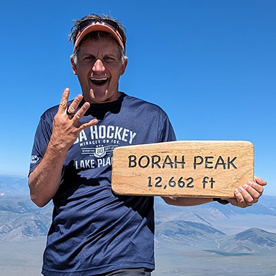
I’ve done Borah Peak 4 times now and always asked the same questions about this state’s highpoint:

1) How was the snow bridge?
2) Did you carry spikes?
3) What time did you start?

Before I share my perspective, I’m not even sure why people call it a snow “bridge”.  It’s not bridging any kind of chasm from one one side to the other.  It’s really just a saddle that holds snow well into July.  I think it looks more like an icy drift of snow rather than a bridge, but yeah, maybe it’s just easier to say snow bridge… and it does sound cool too.

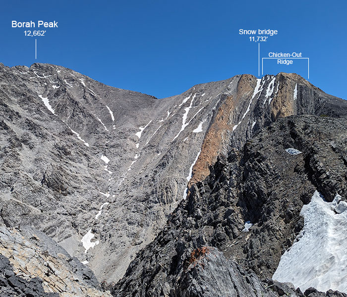
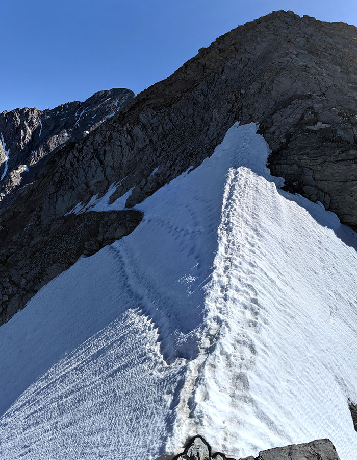
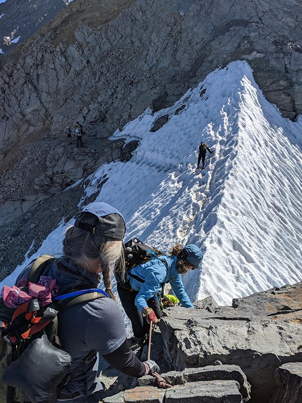
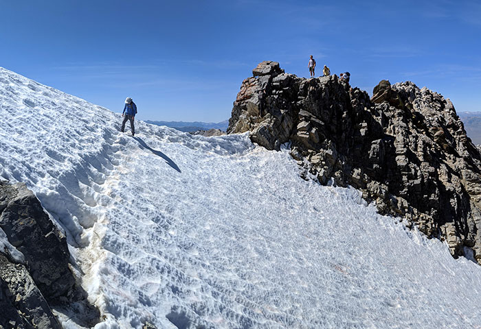
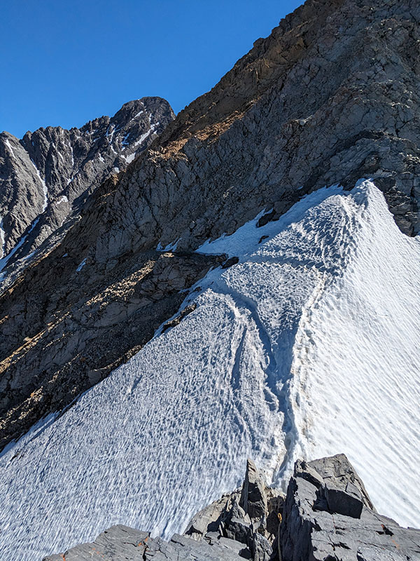
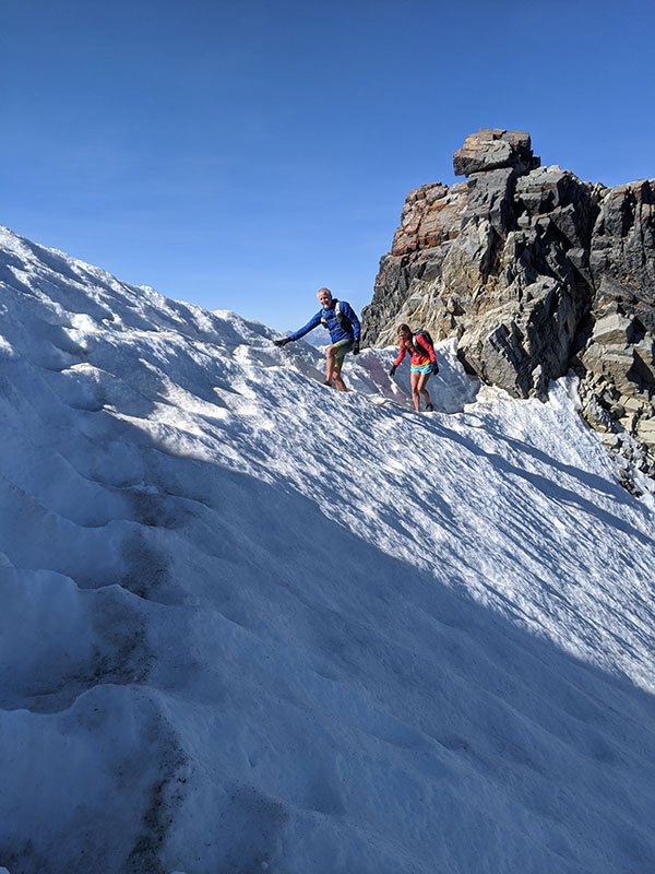
If you’re wondering, what snow bridge?  We’re talking about the super short crossing of hardpack snow immediately after Chicken Out Ridge, about a mile from the summit as shown below.

Now then…

Q) How was the snow bridge?

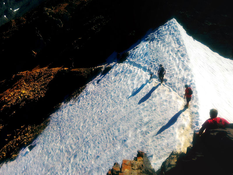
A) The bridge was fine.  It’s always fine.  Although I’ve only ever done this hike on the 3rd weekend of July, that saddle is maybe 20 yards across and always with decent pockets from previous foot traffic.

#1 – My first time summiting Borah was on July 19, 2014.

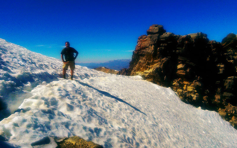
Nothing about crossing this patch of snow for the first time made me nervous, including not finding a handline to get down off Chicken Out Ridge.  I was actually glad to figure this out without using a rope.

#2 – The second time I submitted Borah was on July 20, 2019.

No handline to get down off Chicken Out Ridge this year either.  No problem, it’s not necessary.

#3 – My third summit was on July 18, 2020.  Doesn’t look too different from last year now does it?!

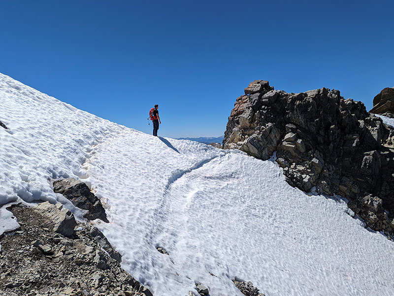
You can see decent pockets again from so much foot traffic.

#4 – Again on July 15, 2023.  Even after a big snow year, the song remains the same (name that band!).

The snow does get a bit soft by mid-afternoon, but it can still be pretty slick and slippery.

So that begs the next question…

Q) Did you carry spikes?

A) No, I have never felt spikes were necessary for such a short stretch this late into the summer.  Some would say ropes, ice axes and crampons are advisable year-round, but I think that’s excessive.  I would absolutely use those tools (minus the rope maybe) if it were Spring.  However, my experiences in July are hardly any condition for that level of mountaineering gear… and again, not even microspikes imo.

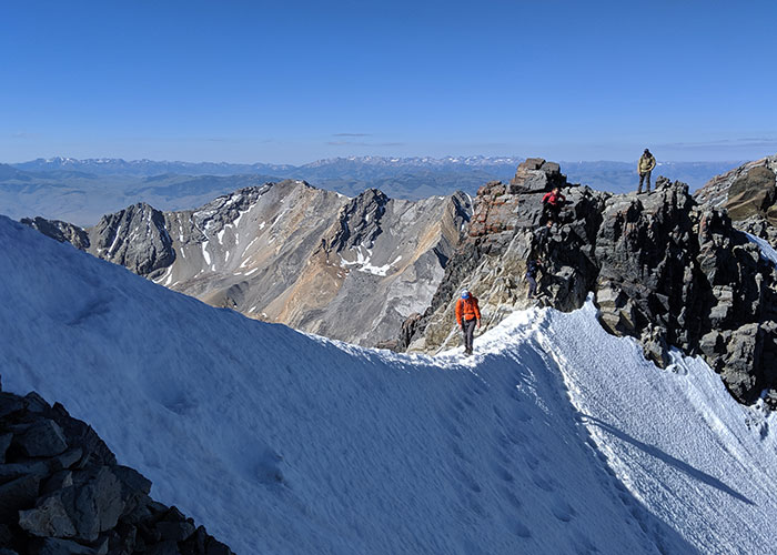
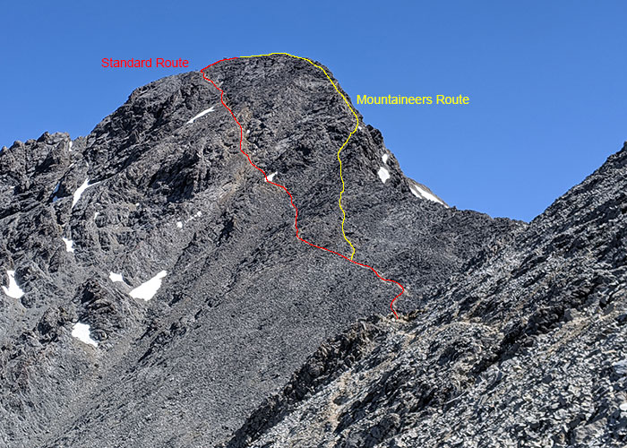
It always looks worse from a distance.  Even intimidating.  Red line is the trail, yellow circles are people.

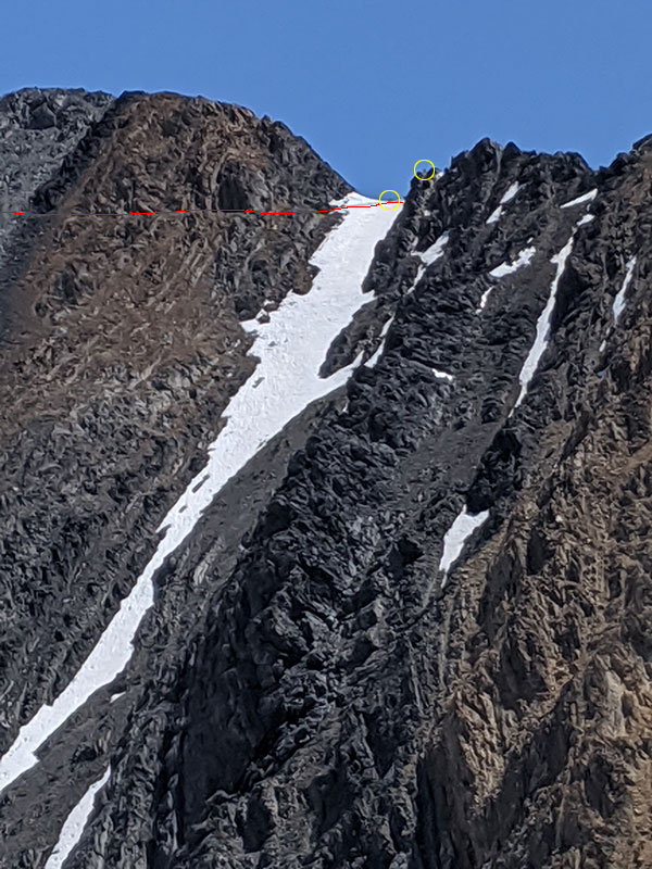
No doubt this slope involves some potential risk of slipping and sliding that would likely end in serious injury or worse.  I wonder if there has ever been any such accident here.

Just take that stretch slow and steady.  You will be across it in less than 60 seconds.

And finally…

Q) What time did you start?

A) I like to start around 7a.  Even though the sign at the trailhead says it takes 6-7 hours to the top and to plan for a 12-hour round trip, it has never taken me that long.  Not even on my worst year.  It’s definitely a challenging hike, climbing over 5,100 feet in 4 miles, but 12 hours??  I would tell you to build up your strength if you think it’s going to take that long.  Do something smaller and work your way up to tackling the likes of Borah.  I think a decent timeframe would be more like 4ish hours up and 3ish hours down.  So 7ish hours total!  Even 8 or 9 hours is reasonable… but definitely not 12.  Train more first!

I still want to reach the summit in under 3 hours without running (I’m a hiker, not a trail runner).
Here are my times so far:

DATE START SUMMIT TIME UP RETURN DONE TIME DOWN TOTAL TIME
2014 6:46a 11:52p 5:06h 12:57p 3:48p 2:51h 7:57h
2019 7:07a 10:41a 3:34h 11:03a 1:35p 2:32h 6:06h
2020 7:08a 10:18a 3:10h 10:51a 1:06p 2:15h 5:25h
2023 7:50a 11:15a 3:25h 11:47a 2:18p 2:31h 5:56h

I also prefer the Mountaineers Route as opposed to the standard trail up.

Now I just need to try this route in real mountaineering conditions!

← Consider Always Roping Up on Glaciers
The Stars Aligned for Rainier →

Leave a Reply Cancel reply

Your email address will not be published. Required fields are marked *

Six months ago today, I stood on top of the tallest peak in the Americas — Aconcagua, Argentina — and it has taken me that long to finish a series of posts about my epic adventure!

This day-by-day trip report is packed with photos, route descriptions, and insights from my own experience.  You’ll find everything from what to pack, to what the camps are really like, to why I think the 360° Traverse is the ideal choice.

👉 Lnk in bio!

Whether it’s your first high-altitude climb or you’re adding Aconcagua to your mountaineering resume, the 360° Traverse offers one of the most satisfying ways to stand on the highest point in South America.

#aconcagua #climbaconcagua #aconcagua360 #360traverse #highpoint #highpointing #highestpoint #tallestpeak #andes #andesmountains #argentina #sevensummits #7summits #highaltitude #6961 #trekking #mountaineering #inka #inkaexpediciones #expedition #adventure #adventuretime #adventuretravel #adventures #climbhigh #climbhigher #peakbagging #peakbagger

33 3
Open post by backcountryfever with ID 18058499771589212
Six months ago today, I stood on top of the tallest peak in the Americas — Aconcagua, Argentina — and it has taken me that long to finish a series of posts about my epic adventure!

This day-by-day trip report is packed with photos, route descriptions, and insights from my own experience.  You’ll find everything from what to pack, to what the camps are really like, to why I think the 360° Traverse is the ideal choice.

👉 Lnk in bio!

Whether it’s your first high-altitude climb or you’re adding Aconcagua to your mountaineering resume, the 360° Traverse offers one of the most satisfying ways to stand on the highest point in South America.

#aconcagua #climbaconcagua #aconcagua360 #360traverse #highpoint #highpointing #highestpoint #tallestpeak #andes #andesmountains #argentina #sevensummits #7summits  #highaltitude #6961 #trekking #mountaineering #inka #inkaexpediciones #expedition #adventure #adventuretime #adventuretravel #adventures #climbhigh #climbhigher #peakbagging #peakbagger

My 13th time on this summit, but 1st to enjoy some watermelon at the top 🍉 Thanks to Jocelyn, the "Watermelon Girl", who lugged that all the way up and was gracious enough to share it 😁

#mounttimpanogos #mttimpanogos #mounttimp #timpanogos #timp #11er #goatchallenge #hikethewasatch #summitshot #peakbagger #summervibes #watermelon #watermelongirl #goodvibrations

33 2
Open post by backcountryfever with ID 18494366443068269
My 13th time on this summit, but 1st to enjoy some watermelon at the top 🍉 Thanks to Jocelyn, the "Watermelon Girl", who lugged that all the way up and was gracious enough to share it 😁

#mounttimpanogos #mttimpanogos #mounttimp #timpanogos #timp #11er #goatchallenge #hikethewasatch #summitshot #peakbagger #summervibes #watermelon #watermelongirl #goodvibrations

Summit Shack in Sight!

#mounttimpanogos #mttimpanogos #mttimp #timp #wasatchfront #wasatchmountains #11er #summitshack #mountainlife #hikemore #hikerlife

20 0
Open post by backcountryfever with ID 18350512492156368
Summit Shack in Sight!

#mounttimpanogos #mttimpanogos #mttimp #timp #wasatchfront #wasatchmountains #11er #summitshack #mountainlife #hikemore #hikerlife

Veered right a bit of the South saddle (red line) for a more adventurous route up to Timp... but once we got up on the ridge, we saw we could have done an even more interesting way (yellow line) cutting into that cliff band and zigzagging along the shelves as seen in the 4th picture (taken from South Timp).

#mounttimpanogos #mttimpanogos #mttimp #timp #timpanogos #mountaineering

33 1
Open post by backcountryfever with ID 18083925961775519
Veered right a bit of the South saddle (red line) for a more adventurous route up to Timp... but once we got up on the ridge, we saw we could have done an even more interesting way (yellow line) cutting into that cliff band and zigzagging along the shelves as seen in the 4th picture (taken from South Timp).

#mounttimpanogos #mttimpanogos #mttimp #timp #timpanogos #mountaineering

Only a few patches of snow remain between Aspen Grove and Emerald Lake.

#mounttimpanogos #mttimpanogos #timpanogos #timp #aspengrove #emeraldlake #snowfun #springhiking #wasatchmountains #goatworthy

37 1
Open post by backcountryfever with ID 18330819139163410
Only a few patches of snow remain between Aspen Grove and Emerald Lake.

#mounttimpanogos #mttimpanogos #timpanogos #timp #aspengrove #emeraldlake #snowfun #springhiking #wasatchmountains #goatworthy

For those interested in doing Deseret Peak... the snow is still in the couloirs, but only for a little while longer!

#deseretpeak #twincouloirs #mountaineering

27 1
Open post by backcountryfever with ID 18047137721625663
For those interested in doing Deseret Peak... the snow is still in the couloirs, but only for a little while longer!

#deseretpeak #twincouloirs #mountaineering

The best way to slide down a snowy slope in Spring conditions is like this...

#glissade #glissading #springtimefun #mountaineering #slipperywhenwet #letsgooo

18 1
Open post by backcountryfever with ID 17851034010437154
The best way to slide down a snowy slope in Spring conditions is like this...

#glissade #glissading #springtimefun #mountaineering #slipperywhenwet #letsgooo

Didn`t get much mountaineering in this Spring, so trying to catch the last bit of something before the snow`s all gone.

#mountaineering #snowhike #wolverinecirque #abovebrighton #brighton #springadventures #springhike #westillhavesnow #utahhiking #mtmillicent #mtwolverine #patsymarley #ridgehike

25 0
Open post by backcountryfever with ID 18071868488494094
Didn't get much mountaineering in this Spring, so trying to catch the last bit of something before the snow's all gone.

#mountaineering #snowhike #wolverinecirque #abovebrighton #brighton #springadventures #springhike #westillhavesnow #utahhiking #mtmillicent #mtwolverine #patsymarley #ridgehike

Not too many cold weather weekends left to go winter camping!

#coldweathercamping #wintercamping #wintercamp #uintas #sledsintow #stillwinterhere #winterfun

16 0
Open post by backcountryfever with ID 18363244447130614
Not too many cold weather weekends left to go winter camping!

#coldweathercamping #wintercamping #wintercamp #uintas #sledsintow #stillwinterhere #winterfun
Follow on Instagram

Recent Posts

  • It’s Mountaineering Season in Utah!
  • Echo Flask Hydrogen Water: Next Level Hydration?
  • Bagging Bierstadt from the Winter Route
  • 2025: A Record-Setting Year on Aconcagua
  • Adiós Argentina

Recent Comments

  • Matt on How I Would Do Kings Peak in 1 Day
  • Rich Meziere on Bummed Out By A Broken BOA Binding
  • Backcountry Fever on Bummed Out By A Broken BOA Binding
  • Alex Cook on Bummed Out By A Broken BOA Binding
  • Rick Mandahl on Cold Fusion Couloir to North Timpanogos

RECOMMENDED READING

Categories

  • 14ers
  • Adventure Plans
  • Avalanche Awareness
  • Backpacking
  • Epic Treks
  • Grand Canyon
  • Health & Wellness
  • International Expeditions
  • Mountaineering
  • Pacific Northwest
  • Peak Bagging
  • Product Feedback
  • Reading References
  • Road Trip
  • Scrambling
  • Season Summary
  • Seven Summits
  • Six-Pack Challenge
  • Snowshoeing
  • Social Media
  • State Highpoints
  • Technology
  • Uinta Mountains
  • Uncategorized
  • Uphill Training
  • Wasatch Front
  • Zion
©2025 Backcountry Fever